13. The model of planned economy was adopted in India to address the regional imbalances left behind by colonial rule. Comment. (250 words, 15 marks)
Directions: Intro----- Regional imbalances left by colonial rule + How planning addressed the imbalances + Limitation------Conclusion.
Introduction:
Start by describing the planned economy (or) regional imbalance.
Main Body
Regional imbalances left by colonial rule
- Presidency-based development – Concentrated mostly in Madras, Bombay and Kolkata to facilitate trade with Britain.
- Neglected Hinterland – Coastal regions saw development, whereas interior and princely states were left largely agrarian and disconnected.
- Targeted infrastructure – Rail network and irrigation projects were built specifically to export commercial cash crops, raw materials, etc.
- Agrarian Distress – Because of the Zamindari, Ryotwari and Mahalwari systems, etc.
How did planning address regional imbalances?
- State-Led Industrial planning – Guided by the Mahalanobis Strategy and the Industrial Policy Resolution of 1956 for more industries.
- Industrial dispersal – Establishing more industries in relatively backward areas created employment and economic linkages. Eg: Steel plants at Bhilai (Chhattisgarh), Rourkela (Odisha), etc.
- Balanced regional development – Targeted planning & public investment directed towards backward regions, the state's population and financial backwardness.
- Infrastructure creation – Investments in dams, power, railways, roads and irrigation in infrastructure deficit region.
- Agricultural development – Irrigation, rural credit and agricultural programmes to raise productivity.
Limitations
- Green Revolution – Initially benefited regions with better irrigation and infrastructure, particularly parts of Punjab, Haryana and western Uttar Pradesh.
- Industrial licensing – Licensing policies and public investment often concentrated in certain areas, not always ensuring efficient or equitable regional development.
- Regional disparities – Inter-state disparities persisted, especially between industrialised western/southern states and several eastern and central states.
- Issues with centralisation – Excessive centralisation sometimes weakened state-level initiative and local participation.
Conclusion:
Give a balanced conclusion.
14. Compare the Loo, Chinook and Foehn winds with respect to their regions of prevalence, their nature and climatic impacts. (250 words, 15 marks)
Direction: Intro----Compare Loo, Chinook and Foehn-----Conclusion.
Introduction:
Loo, Chinook and Foehn winds are local winds. So, give the introduction by describing local winds.
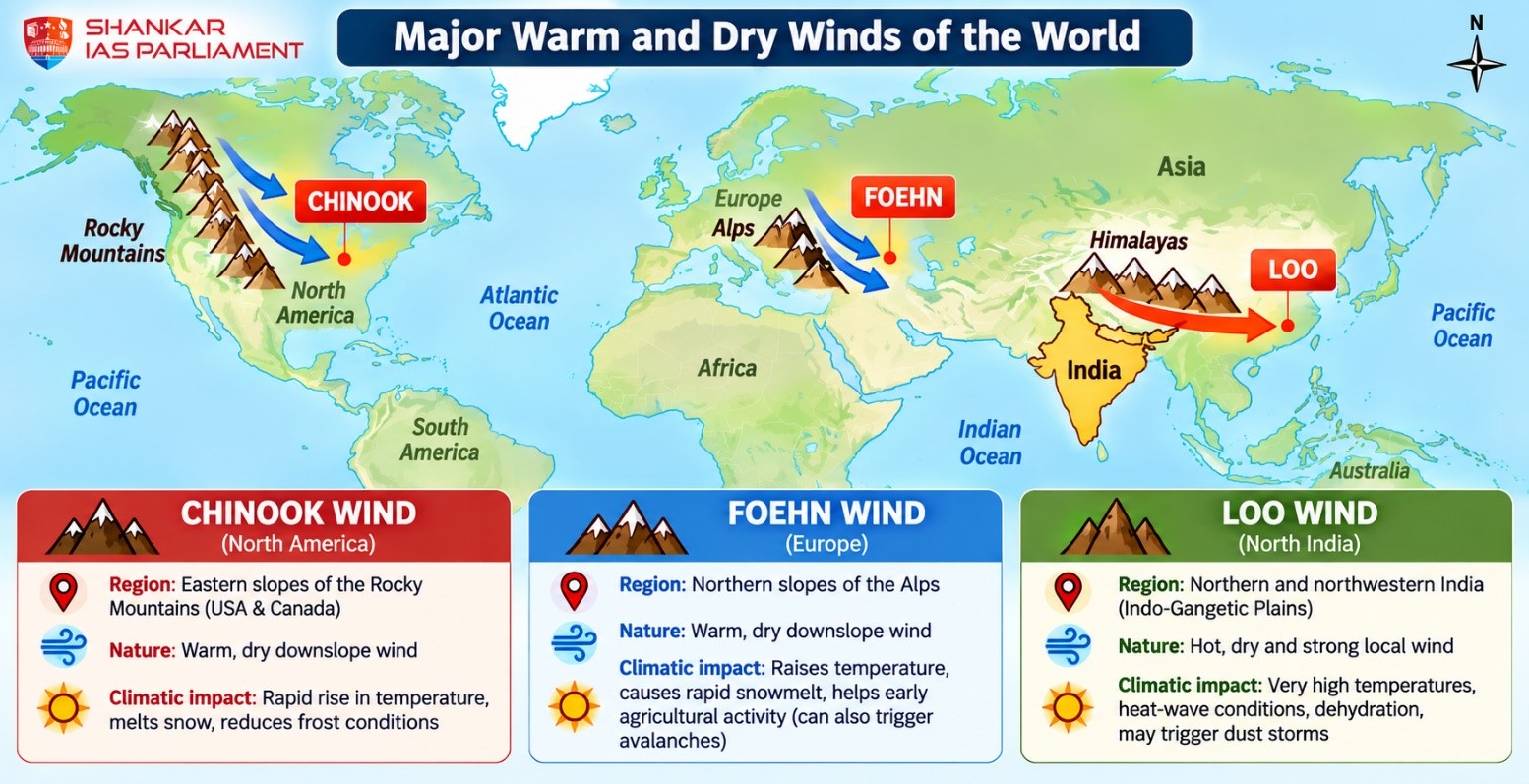
Main Body
|
Features
|
Loo
|
Chinook
|
Foehn
|
|
Regions of prevalence
|
Northern & northwestern India, especially the Indo-Gangetic Plains
|
Rocky Mountains, especially eastern slopes in the USA and Canada
|
Alps of Europe, particularly northern Alpine valleys
|
|
Nature
|
Hot, dry, dusty and strong local wind; Occurs during peak summer afternoon hours.
|
Warm, dry and rapid; occurs mainly in winter/spring as a downslope wind.
|
Warm, dry and gusty. Occurs year-round as a downslope wind.
|
|
Climatic impacts
|
Causes very high temperatures, dehydration and heat-wave conditions; may trigger dust storms; crop damage
|
Rapidly raises temperature, melts snow and can reduce frost conditions.
Also known as snow eater.
|
Raises winter temperature, rapidly melts snow, making land suitable for early agricultural activity,
|
Conclusion:
Give a balanced conclusion by linking all three.
All three can produce dry and warm conditions, significantly shaping regional climate, agriculture and livelihoods.
15. Analyse the role of satellite-based technologies in achieving climate-smart agriculture and food security in India. (250 words, 15 marks)
Direction: Intro---- role of satellite-based technologies------Conclusion.
Introduction:
Describe climate-smart agriculture (or) food security (or) link both.
Main Body
Role of satellite-based technologies in climate-smart agriculture
- Weather forecasting - rainfall, cyclone and temperature forecasts
- Early warnings – Drought, floods
- Climate monitoring
- Disaster response - Rapid assessment of flood, cyclone and drought damage
- Pest & disease control
- Crop monitoring – Track crop health and growth.
- Water management
- Acreage and yield estimation
- Land-use planning – Maps soil, cropping patterns, degraded land and irrigation coverage.
Indian applications
- ISRO's Earth-observation satellites
- FASAL (Forecasting Agricultural output using Space, Agro-meteorology and Land-based observations).
- National Agricultural Drought Assessment and Monitoring System
- Integration of satellite imagery with AI, GIS, drones and IoT-based sensors
Role in Food Security
- Food Availability – better yield forecasting and productivity lead to more available food grains.
- Accessibility – Reduced losses and better targeting of interventions lead to better supply chain enhance nutrition security.
- Income stability for farmers & stability in food supply.
Challenges
- Small and fragmented landholdings.
- Farmers may lack digital literacy and access.
- Cloud cover can limit the usefulness of optical imagery.
- High-resolution data and associated analytics are costly.
- Concerns regarding data ownership, privacy and interoperability need attention.
Conclusion:
Give a balanced conclusion and suggest some measures.


