Mains Syllabus: GS I - Geographical features and their location-changes in critical geographical features.
Why in the News?
India’s coastline has been recalculated as 11,098.81 km from 7,561.60 km, up by 3,537.21 km or nearly 50 %.
What are the challenges in measuring coastal length?
- Coastline Paradox - The British mathematician and physicist Lewis Fry Richardson first identified the coastline paradox in the early 1950s.
- Fractals - French peer Benoît Mandelbrot examined the problem mathematically in 1967 and found that coastlines exhibit properties similar to fractals.
Coastlines are not true fractals in the pure mathematical sense but display fractal-like properties.
- Ruler Dependency – Measurement of the coastal length depends on the length of the measuring stick.
- For example, measuring a coastline with a 200-km-long ruler would smooth over most inlets and bends — but a 50-km ruler would detect them.
- At 1 km, the measurement will capture every estuary, tidal flat, and creek and so the more one refines the scale of the ruler, the longer the total coast becomes.
Why was India’s coastal length increased?
- Change in Calculation Method - Earlier measurements have relied on simplified straight-line distances, whereas the current approach, uses the fractal method.
- This captures every curve and contour, resulting in a more accurate and longer coastline measurement.
- Change in the Scale- The previous estimate of 7516 km from the 1970s banked on maps that displayed India’s coastline at a 1:4,500,000 resolution.
- The more recent updated measurement ,performed by the National Hydrographic Office (NHO) and the Survey of India, used electronic navigation charts at a much finer scale of 1:250,000.
The larger the scale of the map, the greater the length’s outcome, because larger-scale data capture more intricate details like bays, inlets, and minor irregularities that are smoothed out at smaller-scale data.
- Updated High Waterlines - The Survey of India used highwater lines prepared by the NHO based on 2011 data on electronic navigation charts to measure the coastline.
- The highwater line was used as the base reference and river mouths and creeks were closed off at a fixed threshold inland.
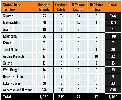
- Addition of Coastline of Individual Offshore Islands - Peripheral coastline (high-water line) of individual offshore islands has been used to calculate coastline length.
- Inclusion of new islands - About 1,389 islands/islets which were not included when the survey was done in 1970 were added to the list, to define the coastal boundaries of all Indian states and Union territories.
|
Length of Coastline of India
|
|
State/UT
|
Coastline Length (km)
|
|
Andaman & Nicobar Islands
|
3,083.50
|
|
Gujarat
|
2,340.62
|
|
Tamil Nadu
|
1,068.69
|
|
Andhra Pradesh
|
1,053.07
|
|
Maharashtra
|
877.97
|
|
West Bengal
|
721.02
|
|
Kerala
|
600.15
|
|
Odisha
|
574.71
|
|
Karnataka
|
343.30
|
|
Goa
|
193.97
|
|
Lakshadweep Islands
|
144.80
|
|
Daman & Diu
|
54.38
|
|
Pondicherry (Puducherry)
|
42.65
|
|
Total
|
11,098.81
|
The revised coastline will be reviewed every 10 years using updated datasets.
What are the implications of updated coastal length?
- Maritime Security - A longer coastline means a longer length to protect and recalibrate its maritime security framework.
- Disaster Preparedness - India has 11 coastal States and two large island groups, faces regular cyclones, and is especially vulnerable to sea-level rise.
- Understanding the true extent of the national coast can thus help refine climate models, coastal zoning regulations, and disaster response strategies.
- Updating the Economic Zone - The revision impacts the calculation of India’s Exclusive Economic Zone (EEZ), potentially expanding rights over marine resources, including fisheries, oil, gas, and minerals.
- Coastal Regulation – Changes in coastal length requires updating Coastal Regulation Zone (CRZ) norms and coastal zone management plans, which govern construction, development, and conservation along the coast.
- Better Planning and Policy Making - The revised measurements inform better planning for coastal infrastructure, including ports, industrial zones, and tourism projects.
- Updating Learning Materials – The official announcement of the updated length needs to be updated in all the relevant books.
References
The Hindu | Coastline Paradox
To Practice Mains Question, Click Here.