Mains: GS III - Science and Technology- Developments and their Applications and Effects in Everyday Life| Achievements of Indians in Science & Technology| Indigenization of Technology and Developing New Technology
Why in News?
The Indian Space Research Organisation (ISRO) is planning to launch the NISAR satellite from Sriharikota on July 30 on board a GSLV Mk-II Rocket.
What is NISAR satellite?
- NISAR – It stands for NASA-ISRO Synthetic Aperture Radar
- Built by – It is a joint mission of NASA and ISRO.
- Launch vehicle – GSLV Mk-II
- GSLV Mk-II – It is also known as LVM3 (Launch Vehicle Mark 3), a three-stage Indian launch vehicle developed by ISRO.
GSLV Mk-II is designed to launch heavy satellites, particularly those weighing around 4 tons to geostationary transfer orbit (GTO) or about 10 tons to low Earth orbit (LEO).
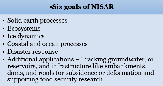
- Aim – To study changes on the earth’s surface in fine detail, covering earthquakes, volcanoes, ecosystems, ice sheets, farmland, floods, and landslides.
- Mission duration – It is for three years.
- Design lifetime – At least five years.
- Synthetic Aperture Radar (SAR) – It is a type of radar that uses the motion of a radar antenna to create high-resolution images of the Earth's surface or other objects.
- Aperture – It refers to the opening used to collect radar data.
- The longer the opening, the better the radar's ability to distinguish between two closely spaced objects.
- Radar – It is an acronym for Radio Detection and Ranging.
- It is a system that uses radio waves to detect, locate, and track objects, as well as measure their speed and other characteristics.
- Working of radar – It works by transmitting radio waves and analysing the echoes that bounce back from objects in its path.
How was NISAR built?
- Contribution of ISRO – I‑3K spacecraft bus,4 kW of solar power, the entire S‑band radar electronics, high‑rate Ka‑band, telecom subsystem.
- A gimballed high‑gain antenna, End‑to‑end launch services and documentation.
- Contribution of NASA – The complete L‑band SAR system, all radio‑frequency electronics, a 12‑m antenna, a 9-m carbon-composite boom (the instrument structure that carries both radars.),
- The supporting avionics, including a high‑capacity solid‑state recorder, a GPS receiver, an autonomous payload data system, Ka‑band payload communications subsystem.
I‑3K spacecraft bus is the platform that houses the controls to handle command and data, propulsion, and attitude.
- combining of Parts – The spacecraft was to be integrated at the ISRO Satellite Centre in Bengaluru after the two radars were coupled at Jet propulsion laboratory (JPL) in USA.
- The final observatory‑level tests – It has taken place on Indian soil.
- Mission procedures – The mission operations are to be centred at the JPL Mission Operations Centre.
How NISAR will be operated by US and India?
- Flight operations – Day‑to‑day flight operations will be led from the ISRO Telemetry, Tracking and Command Network in Bengaluru.
- Transfer of data – Most of its data will be sent through NASA’s Near-earth Network facilities in Alaska, Svalbard (Norway), and Punta Arenas (Chile).
- They can together receive around 3 TB of radar data per day.
- They will be complemented by ISRO’s ground stations in Shadnagar and Antarctica.
- Processing of data – India’s National Remote Sensing Centre will process and distribute all data required for Indian users.
- Earmarking the S-band – Although NISAR will operate globally at L‑band, ISRO has reserved routine, planned acquisitions with the S‑band SAR over India.
- The S-band acquisitions have extended sensitivity to biomass, better soil‑moisture retrieval, and mitigate ionospheric noise.
- Prominence to L-band – Because the L‑band radar is the principal tool for NASA’s mission goals, the instrument is expected to operate in up to 70% of every orbit.
- Reduction of conflicts – Operating both radars together is an official implementation goal so that mode conflicts over the Indian subcontinent are minimised.
How does NISAR work?
- Placing of satellite – Once it is launched, NISAR will enter a sun-synchronous polar orbit.
- It will be placed at 747 km altitude and an inclination of 98.4º.
- Bouncing of radar waves – From here, instead of snapping pictures, the SAR will bounce radar waves off the planet’s surface.
- It measures how long the signal takes to come back and how its phase changes.
- Recording the echoes – As the spacecraft moves forward, it transmits a train of radar pulses and records the echoes.
- Combining of echoes – A computer coherently combines all those echoes.
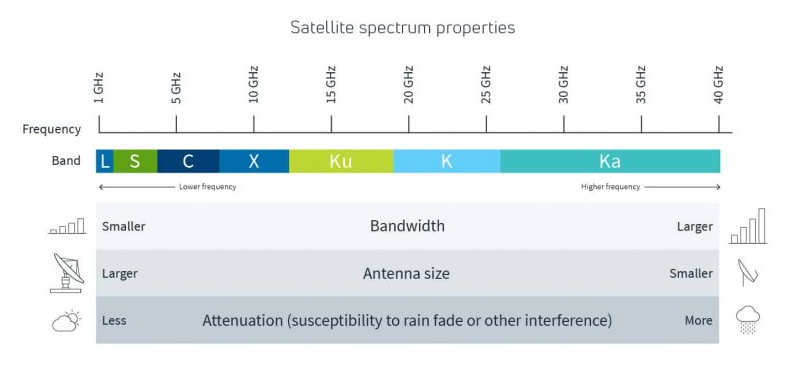
- NISAR will combine an L-band SAR (1.257 GHz), which uses longer-wavelength radio waves to track changes under thick forests and soil and deformations on the ground.
- S-band SAR (3.2 GHz), which uses shorter-wavelength radio waves to capture surface details, such as crops and water surfaces.
- Use of different polarisation – SAR will transmit and receive radar signals with horizontal or vertical polarisation.
Polarisation is the direction in which the electric field of some electromagnetic radiation, like radio waves, oscillates.
- It will allow the instruments to identify the structure and types of different surface materials, like soil, snow, crop, or wood.
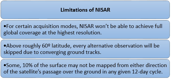
- Bandwidth – The breadth of the bands on the ground the SARs will scan, is an ultra-wide 240 km.
- Transmission of Beam – This scan‑on‑receive method allows the 240‑km swath without compromising resolution.
- Scan results – The resulting scans will have a spatial resolution of 3-10 m and centimetre-scale vertical mapping.
For example, it is enough to spot impending land subsidence in cities
- Operational extent – Each spot on the ground will be scanned once every 12 days.
What are the significances of NISAR?
- Dual band radar – It is the first major earth-observing mission with a dual-band radar.
- It will allow to observe changes more precisely than any other satellite.
- All weather usage – It will be able to see through clouds, smoke, and even thick vegetation, both at day and night.
- Descriptions of climate changes – It provide critical information by taking snapshots of the constantly changing earth’s surface.
- Periodical maps – It will produce annual maps of aboveground woody biomass of 1 ha resolution.
- It will also produce quarterly maps of active and inactive cropland.
- High-resolution maps of flooded versus dry areas will be available.
- Proxy maps data – It can also collect data for damage proxy maps during disasters.
- The maps will be delivered within five hours.
- Free availability of data – The data will be freely available to all users.
Reference
The Hindu| NISAR Satellite