Strengthening India's Indigenous Navigation Capabilities
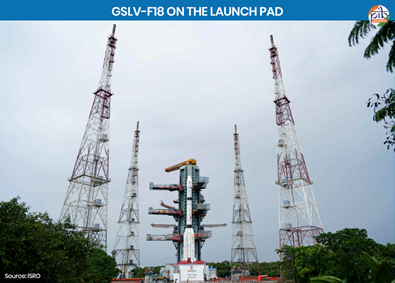
- ISRO successfully launched the GSLV-F18/NVS-03 mission on 30 October 2026 from Satish Dhawan Space Centre, Sriharikota.
- The mission placed NVS-03 into Geosynchronous Transfer Orbit (GTO), strengthening India's indigenous navigation system, NavIC.
Key Highlights of the Mission
- 20th GSLV Flight: The mission marked the 20th flight of India's Geosynchronous Satellite Launch Vehicle.
- Third-Generation Satellite: NVS-03 is the third satellite in the second-generation NavIC series (NVS-01 to NVS-05).
- Orbital Placement: The satellite entered GTO and is being manoeuvred towards its designated orbital slot at 111.75° East.
- Satellite Weight: NVS-03 weighs approximately 2,250 kg.
- Enhanced Signals: It carries navigation payloads in L1, L5 and S frequency bands, improving compatibility and navigation capabilities.
- Indigenous Technology: It carries an indigenously developed atomic clock alongside procured clocks for precise timing.
- Wider Applications: It strengthens Positioning, Navigation and Timing (PNT) services for transportation, aviation, maritime operations and disaster management.
What is a Satellite Navigation System?
- A satellite navigation system uses a network of satellites to provide positioning, navigation and timing information.
- Receivers use signals from multiple satellites to determine their location, speed and direction.
- Applications: Route navigation, aircraft tracking, precision agriculture, disaster management and telecommunications.
- Examples: GPS (USA), GLONASS (Russia), Galileo (European Union), BeiDou (China) and NavIC (India).
What is Geosynchronous Satellite Launch Vehicle (GSLV)?
- GSLV is a three-stage launch vehicle developed by ISRO to place satellites into Geosynchronous Transfer Orbit and Low Earth Orbit.
- Cryogenic Upper Stage: Its indigenous upper stage uses liquid hydrogen as fuel and liquid oxygen as oxidiser.
- Self-Reliance: Indigenous cryogenic technology replaced Russian-supplied stages, strengthening India's advanced launch capabilities.
- GSLV-F18: It is approximately 50 metres tall, weighs 420 tonnes at lift-off and carried the 2,250 kg NVS-03 satellite.
NavIC
- NavIC, formerly called Indian Regional Navigation Satellite System (IRNSS), is India's indigenous regional satellite navigation system developed by ISRO.
- It provides Positioning, Navigation and Timing (PNT) services through satellites and ground stations.
- Coverage: It covers India's landmass and approximately 1,500 km beyond its geopolitical boundary.
- Original Constellation: It consists of seven satellites—three in geostationary orbit and four in inclined geosynchronous orbit.
- Frequency Bands: The next-generation NVS satellites introduce L1 alongside the existing L5 and S bands.
What are the Two Types of NavIC Services?
- Standard Positioning Service (SPS): An open navigation service available to civilian users and interoperable with other global navigation systems.
- Restricted Service (RS): An encrypted navigation service exclusively available to authorised strategic users.
What is the Progress of the Next-Generation NVS Series?
The five-satellite NVS series aims to improve NavIC's coverage, reliability and continuity.
|
Satellite
|
Key Details
|
|
NVS-01
|
Launched on 29 May 2023 through GSLV-F12; carries L1, L5 and S payloads and an indigenous Rubidium atomic clock.
|
|
NVS-02
|
Launched on 29 January 2025 through GSLV-F15; orbit-raising failed due to oxidiser valve malfunction.
|
|
NVS-03
|
Launched on 30 October 2026 through GSLV-F18; carries L1, L5 and S payloads.
|
|
NVS-04 and NVS-05
|
Upcoming satellites intended to strengthen NavIC capabilities.
|
NavIC Strengthening India's Space Sovereignty
- Strategic Independence: Reduces dependence on foreign navigation systems for critical national applications.
- National Security: Strengthens indigenous navigation support for strategic and defence operations.
- Technological Self-Reliance: Promotes domestic development of satellites, atomic clocks and advanced launch technologies.
- Economic Applications: Supports transportation, agriculture, aviation, maritime activities and disaster management.
- Atmanirbhar Bharat: Strengthens India's capacity to independently design and operate strategic space infrastructure.
Conclusion
- The NVS-03 mission marks an important milestone in strengthening India's indigenous satellite navigation capabilities.
- Expanding NavIC will enhance strategic autonomy, technological self-reliance and India's position in the global space sector.
Reference
PIB