Why in news?
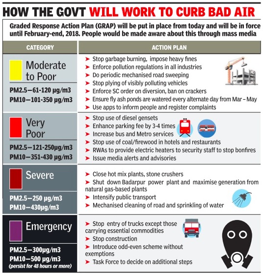
As the Air Quality Index (AQI) in Nation Capital Region dipped to the ‘severe’ category, Stage 4 of the Graded Action Plan (GRAP) has kicked in.
What exactly is the cause for Delhi’s air pollution?
- Air pollution in Delhi, and the whole of the Indo Gangetic plains, is a complex phenomenon that is dependent on a variety of factors.
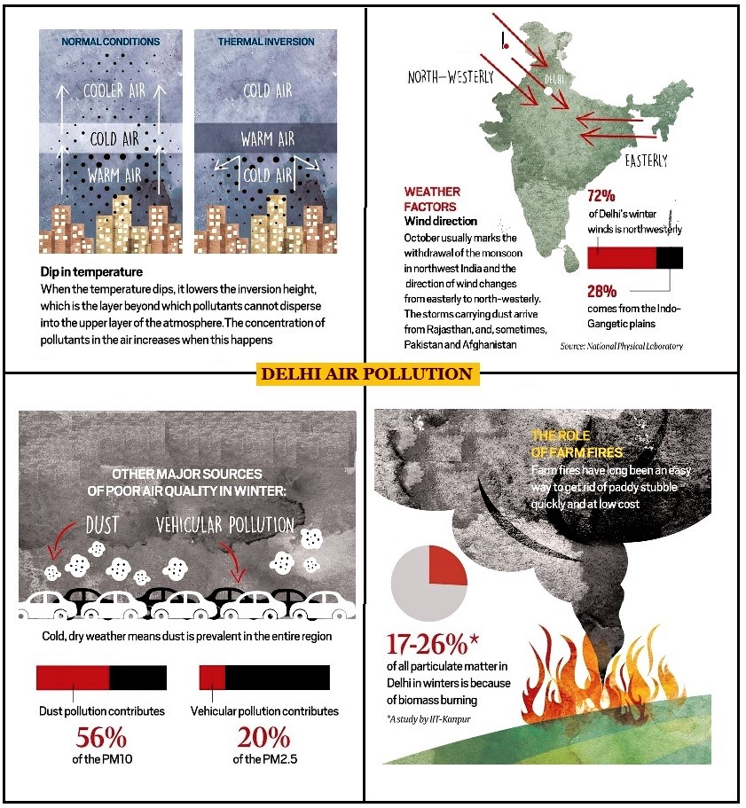
- Dust - Road dust along with construction and demolition dust is the most prominent polluter of air.
- Vehicles - Vehicles are the second largest polluter, with 20 % of PM 2.5 load and approximately 9 % of PM 10.
- Thermal plants - The coal thermal plants in the immediate 300-km periphery of Delhi and industrial point sources also contribute to the pollution.
- Open burning - Open burning of waste by neighbourhoods and municipalities, stubble burning, Diwali crackers, etc. adds to this issue.
- Geography - The geographical nature of the region makes Delhi a pollution trap with weather and wind speed playing a key role.
What is the role of weather in Delhi’s air pollution?
- Wind direction - During the southwest monsoon, the prevalent direction of the wind is easterly.
- The winds travel from over the Bay of Bengal, carrying moisture and rainfall to this part of the country.
- Once the monsoon withdraws, however, the predominant direction of the winds changes to north-westerly.
- These winds carry particulate matter (essentially smoke and soot) from crop-burning in Punjab to the area above Delhi, and then onward down the Gangetic basin.
- Fall in air temperature - As it gets cooler, the inversion height (the layer beyond which pollutants cannot disperse into the upper atmosphere) comes down.
- When that happens, larger concentrations of pollutants in the air hang closer to the surface, and lead to worsening AQIs.
- In summer, the ventilation is very strong and the land is so hot that pollutants rise high and dissipate.
- But in October-November, the pollutants are like a lid sitting above the entire Indo-Gangetic basin, perhaps at a height of 1 km.
What about the geography of Delhi?
- Geography plays a major role not just in Delhi, but also in the Indo-Gangetic basin that extends from Haryana in the west to the middle of Bihar in the east.
- This area is like a long valley surrounded by higher structures (Malwa and Deccan plateaus, Aravalli Mountains, the Himalayas).
- This topography makes the Indo-Gangetic plain similar to California, which is peculiarly susceptible to pollution.
References
- The Indian Express│Delhi’s geography and weather conditions are also fouling its air
- The Indian Express│ What is GRAP, Delhi-NCR’s action plan to combat rising air pollution?
Quick facts
Graded Response Action Plan
- GRAP is a set of emergency measures that kick in to prevent further deterioration of air quality once it reaches a certain threshold in the Delhi-NCR region.
- The GRAP was formulated in 2016 and approved by the Supreme Court in the same year.
- It was notified in 2017 by the Centre, and draws its authority from this notification.
- It was planned after several meetings of EPCA (Environment Pollution (Prevention and Control) Authority) with state government officials and experts.
- The plan is incremental in nature.
- Only when the air quality shifts from poor to very poor, the measures listed have to be followed.
- If air quality reaches the severe stage, GRAP talks about shutting down schools and implementing the odd-even road-space rationing scheme.