Mains: GS I | III – Geography | Disaster Management
Recent Nepal–China border floods in the Bhotekoshi–Trishuli rivers killed 500+ people, exposing Himalayan transboundary climate vulnerability.
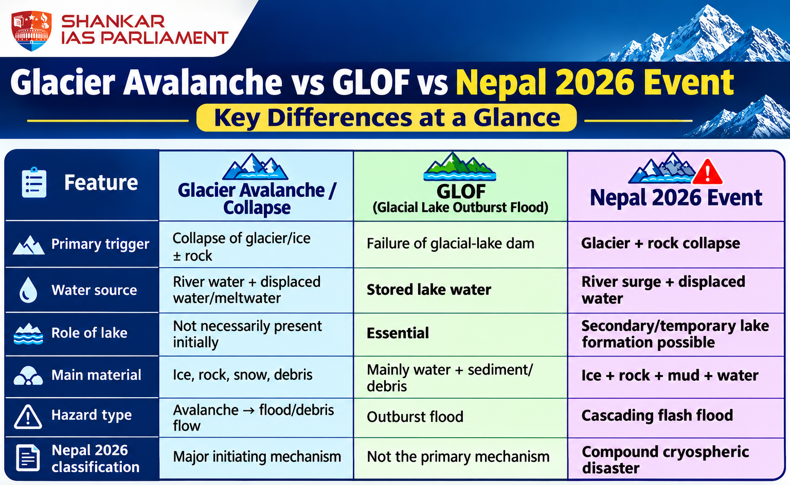
Glacier Collapse incident – At approximately 5,200 m near Langtang Lirung, a large glacier-ice–rock mass collapsed and descended 1,200 m into Lhende Khola.
As it moved downslope, it accumulated additional debris, ice, and water, resulting in a rapidly moving and destructive debris flow.
River blockage and sudden surge – Debris obstructed the river, resulting in water accumulation behind the barrier.
The abrupt failure of this barrier released a surge into the Bhote Koshi–Trishuli, affecting communities located nearly 140 kilometres downstream.
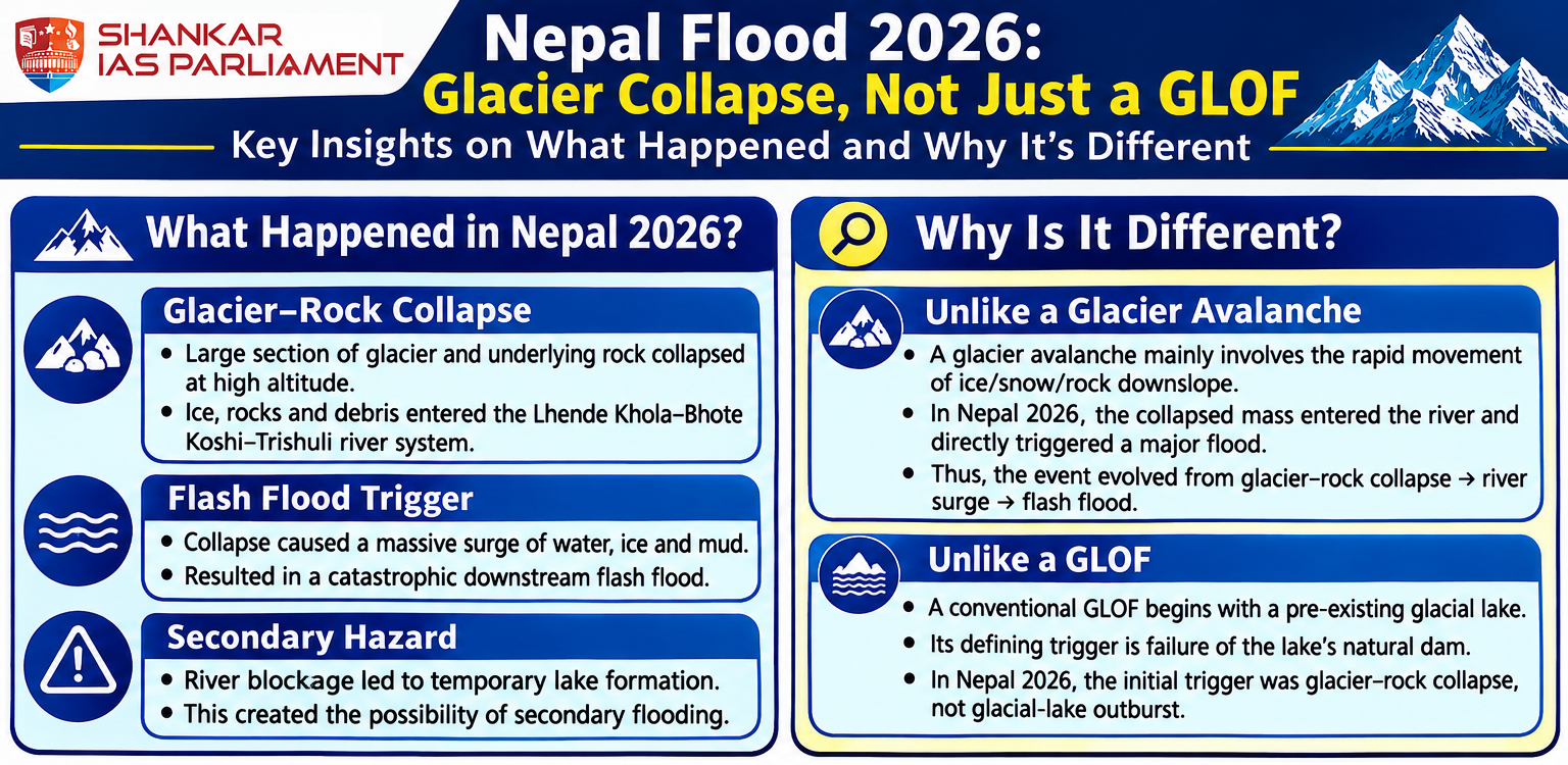
“Earthquake-like” signal – The United States Geological Survey (USGS) identified seismic waves originating from a glaciated cliff collapse rather than tectonic activity.
Approximately three hours later, a subsequent event released energy equivalent to a magnitude 4.2 earthquake, producing signals similar to those of an earthquake.
Satellite imagery – ISRO’s National Remote Sensing Centre (NRSC), including Sentinel‑2 and Resourcesat‑2A, reveals significant alterations at the northern cliff of Langtang Lirung, confirming the occurrence of a collapse.
These visual observations corroborate seismic data that identify the source as a glaciated mountain cliff.
Transboundary Linkages with China – A 72 km stretch along the Nepal–Tibet border was devastated by a flash flood, causing heavy casualties and widespread damage on both sides.
Destruction of port – The collapse destroyed China’s $175.8 million Gyirong Port, which served as the primary trade and tourism gateway between Nepal and China.
Transboundary Impacts on India
Flood Inundation – Rivers originating in Nepal, such as the Trishuli, Narayani, Gandak, and Kosi, contribute significantly to the water flow in Indian river basins, including the Ganga.
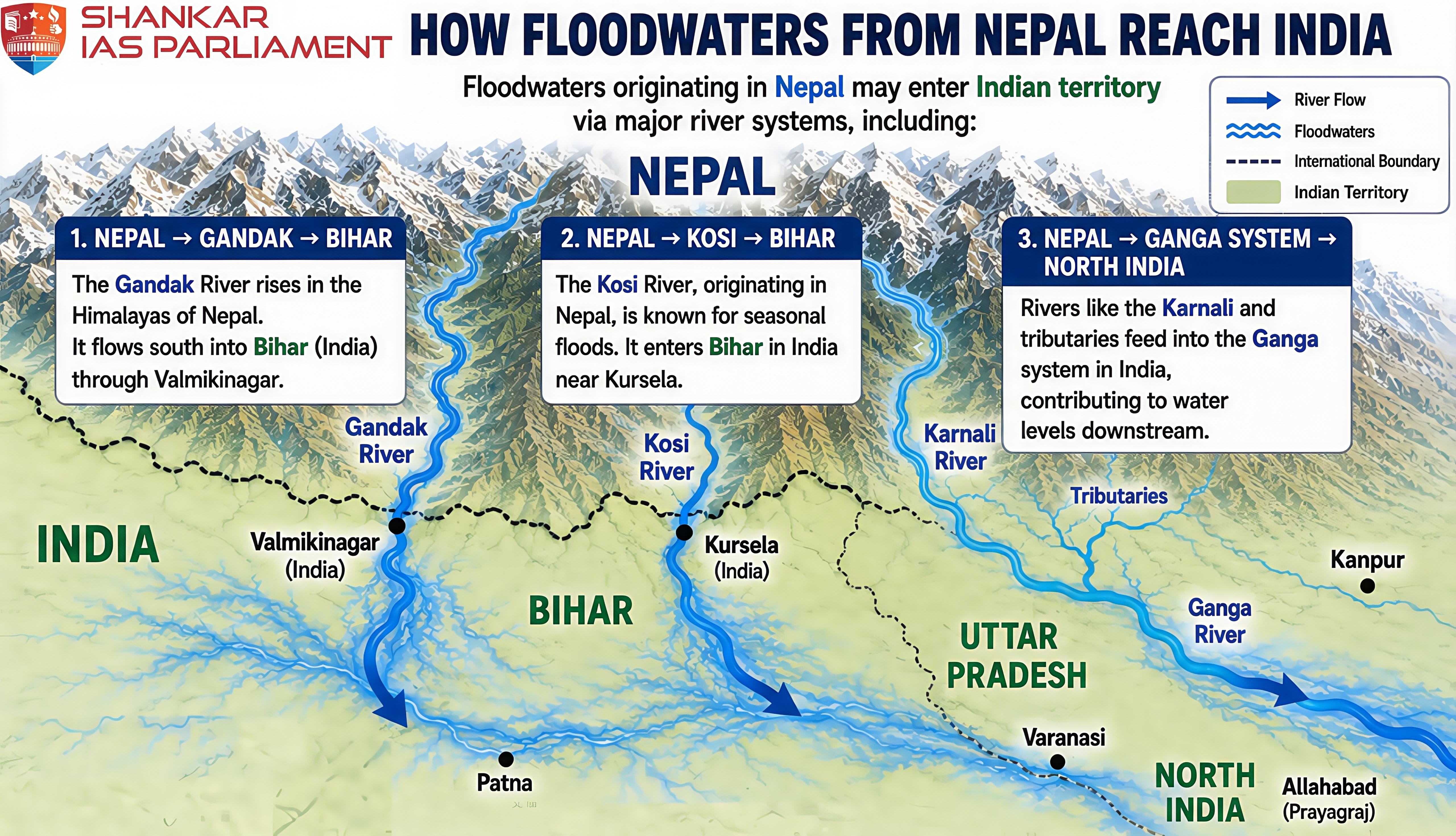
Mass Evacuations – The states of Bihar, Uttar Pradesh, and Uttarakhand have issued high alerts, resulting in the evacuation of thousands of residents.
Human Toll – Floodwaters transported victims’ bodies approximately 240 kilometres into Indian territory.
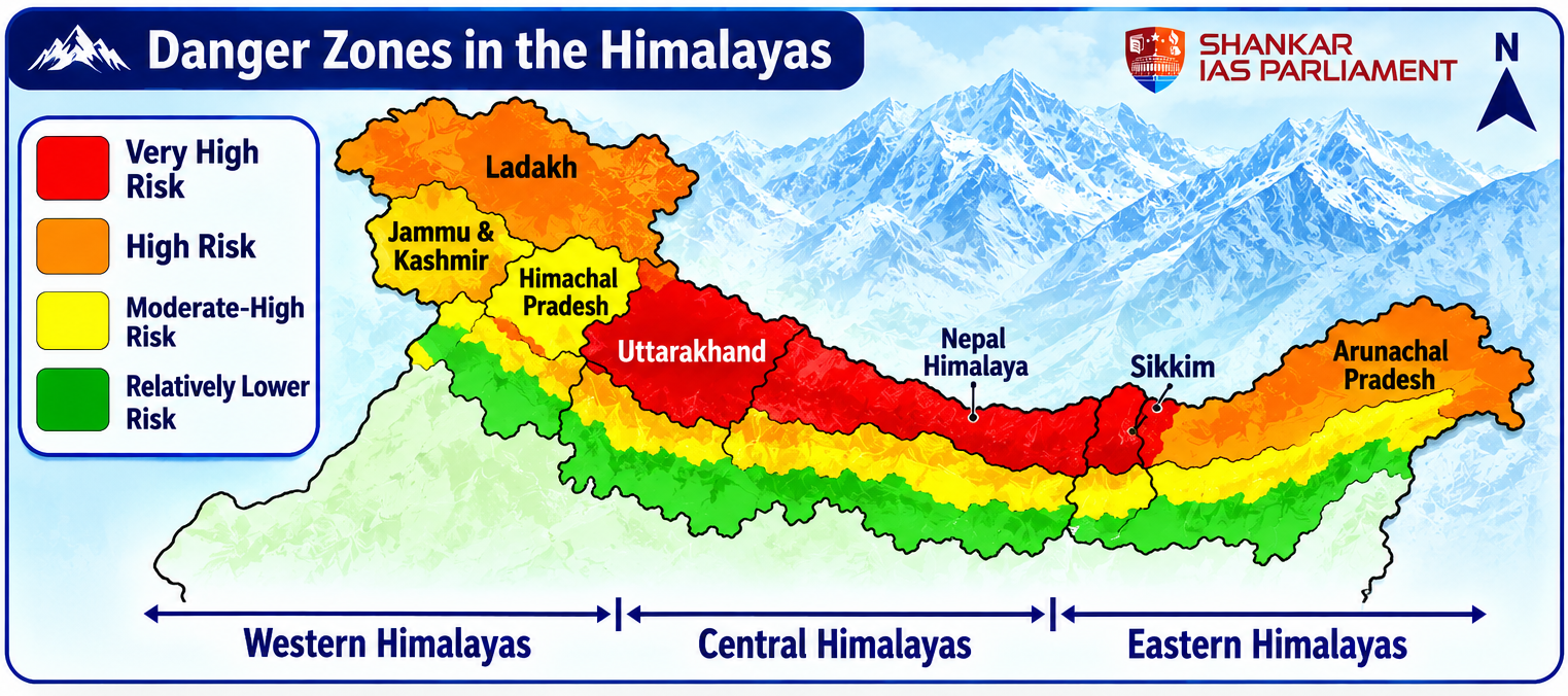
Himalayan Vigilance – Authorities in Uttarakhand have intensified monitoring of glaciers and lakes to prevent similar flood breaches in the future.
|
Himalayan Vulnerabilities |
|
Unpredictability – While hazardous conditions can be identified, the precise timing of glacier collapse cannot be forecast, analogous to the 'last straw' effect.
Sudden Failure – Steep glaciers can remain apparently stable for extended periods before experiencing abrupt failure.
Multiple Factors – Glacier stability is influenced unpredictably by temperature, meltwater, crevasses, bedrock instability, permafrost, and freeze–thaw cycles.
Absence of Predictive Systems – In contrast to earthquakes, there is currently no reliable system for predicting the timing of glacier collapse.
Limitations of Satellite Monitoring – Satellite systems primarily observe changes rather than predict sudden failures.
Monitoring is constrained by revisit intervals, cloud cover, resolution limitations, and inaccessibility of high-altitude regions.
Flood Forecasting Systems in Bihar and Uttar Pradesh
Hydrological models facilitate real-time flood prediction.
Integration of Indian Meteorological Department rainfall data and satellite imagery enhances prediction accuracy.
Community alerts are disseminated through mobile networks and local administrative channels.
Embankment Monitoring Mechanisms
Structural audits involve regular inspections along the Ganga River and its tributaries.
Remote sensing technologies and drones are employed to detect structural vulnerabilities.
Preventive reinforcement measures are implemented to reduce the risk of embankment breaches during the monsoon season.
Deployment of River-Level Sensors
Internet of Things (IoT) sensors provide continuous monitoring of river water levels.
Collected data are transmitted to centralized flood control rooms to facilitate early warning dissemination.
This system improves the accuracy of flash flood and embankment breach predictions.
Development and Updating of Evacuation Plans
District-level maps are prepared to designate safe routes and evacuation zones.
Mock drills are conducted in collaboration with local communities.
Evacuation plans are updated annually based on newly available floodplain and risk assessment data.
National Disaster Response Force (NDRF) Preparedness
Specialised battalions are stationed in districts identified as vulnerable.
Essential equipment, including boats, drones, medical kits, and communication devices, is maintained for rapid deployment.
Capacity-building initiatives include joint training exercises with State Disaster Response Forces (SDRFs) to enhance coordinated response.
Trilateral Mechanism – India, China, and Nepal could collaboratively establish a dedicated framework known as the Himalayan Disaster Coordination Mechanism.
This mechanism would focus exclusively on the following priority areas.
Early warning systems.
Flood management.
Landslide mitigation.
Glacial hazard management.
Search and rescue operations.
Humanitarian assistance.
This approach would ensure that disaster cooperation remains distinct from broader geopolitical disputes.
Real-Time Data Sharing – Countries should exchange the following types of data as rapidly as possible:
River water levels
Rainfall data
Glacier movement
Glacial lake levels
Landslide warnings
Flood forecasts
Meteorological information
Proposed Data Sharing Models
Unidirectional flow – China to Nepal to India
Bidirectional flow – China, Nepal, and India exchange data mutually.
Timely dissemination of real-time information enables downstream communities to undertake critical evacuation measures.
Joint Early-Warning System – A Himalayan Transboundary Early Warning System should be developed utilising the following technologies:
Satellite observation
Weather radar systems
River gauge networks
Seismic monitoring stations
Artificial intelligence-based flood forecasting
Remote sensing technologies
Automated alert dissemination
Objective – To ensure a streamlined process, such as Detection, prediction, alert dissemination, and evacuation.
Joint Search and Rescue Protocol – It is recommended that the three countries establish standardised protocols for the following areas:
Cross-border rescue
Helicopter operations
Medical evacuation
Emergency shelters
Rescue equipment
Missing-person coordination
Foreign tourist assistance
Such coordination is especially critical in remote Himalayan regions, where logistical challenges can impede timely rescue operations.
Protection of Critical Infrastructure – Infrastructure must be designed to address disaster risks that span multiple countries.
Priority Areas for Protection:
Hydropower plants
Bridges
Road networks
Border crossing facilities
Telecommunications infrastructure
Electricity transmission systems
River embankment structures
Airport facilities
Critical infrastructure requires disaster-resilient engineering rather than reliance on conventional construction methods.
Create Humanitarian Corridors – In the event of a major disaster, it is recommended that political and administrative restrictions be temporarily relaxed to facilitate the following:
Food
Medicine
Rescue teams
Emergency equipment
Fuel
Temporary shelters and rapid delivery of these resources to affected populations.
Joint Disaster Exercises – India, China, and Nepal should periodically conduct joint simulation exercises.
Objective – To address the following scenarios: Glacial collapse, flash flooding, border disruption, and downstream flooding.
Such exercises would evaluate the interoperability and effectiveness of their respective emergency response systems.
A disaster originating in the Himalayas can quickly escalate into a transboundary crisis affecting Nepal, China, and India.
Consequently, these countries should transition from a perspective of “My territory, my disaster” to one of “Shared ecosystem, shared risk, shared responsibility.”