0.1237
7667766266
x

Cloud Burst in Himachal Pradesh

iasparliament Logo
August 25, 2023

Why in news?

Himachal Pradesh witnessed a heavy rainfall along with landslides in which at least 22 people died.

What is a cloud burst?

According to the Indian Meteorological Department, an event of extremely heavy rainfall is determined as a cloudburst when "10 cm rainfall is received at a station in one hour”
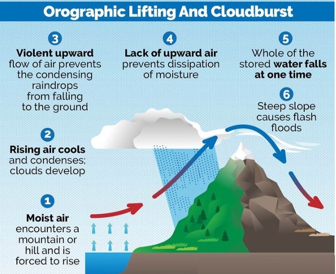
  • It is an extremely high amount of precipitation in a short span of time.
  • It is a localised but intense rainfall activity that can cause widespread destruction, especially in hilly regions.
  • Region- It usually occurs over a small geographical region (20-30 sq.km).
  • Criteria- Rainfall of 10 cm or more in an hour over a roughly 10 km x 10-km area is classified as a cloudburst event.
  • By this definition, 5 cm of rainfall in a half-hour period over the same area would also be categorized as a cloudburst.
  • Mechanism- It happens when saturated clouds are unable to produce rain because of the upward movement of very warm current of air.
  • Cloud formation- This updraft movement of warm wind along with clouds forms the Cumulonimbus clouds.
  • It can grow up to 12-15 km in height through the entire troposphere (occasionally up to 21 km) and can hold huge amounts of water
  • Instead of dropping down, raindrops get bigger in size and get pushed up due to the air current.
  •  Eventually they become too heavy to hold and drop down, leading to more rain than usual.

cloudbursts

What are the causes of cloud burst?

  • Monsoon- It often occurs during monsoon season when the South West Monsoon winds bring in large amount of moisture which fuels the cloudburst.
  • Orographic lift- It is affected by factors like local topology, wind systems, and temperature gradients between the lower and upper atmosphere.
  • Thunderstorm- It is caused due to excessive amount of condensation in the cloud during thunderstorm.
  • Climate change- Global warming is leading to more evaporation of water and because of this dense cumulonimbus clouds are forming, resulting in intense rainfall.
    • Even 1 degree Celsius rise in global temperature can cause change in monsoon extremes and frequent cloudburst.

What are the areas prone to cloudburst?

  • Regions more prone-
    • The Himalayas
    • Western Ghats
    • Northeastern hill States of India
    • Coastal regions
  • Landslides- The heavy spells of rain on the fragile steep slopes trigger landslides, debris flows, and flash floods, causing large-scale destruction and loss of people and property.
  • Coastal cities- They are particularly vulnerable to cloudbursts since the flash floods make the conventional stormwater and flood management policies in these cities dysfunctional.
    • Example- Chennai Floods 2015.

Recent cloudbursts

  • Himachal Pradesh-2003
  • Ladakh-2010
  • Uttarakhand-2013
  • Northeastern states and Western Ghats- 2022 monsoon

What are the consequences of cloud burst?

  • Landslide- The movement of rocks or debris on a slope downwards is called as Landslide.
  • Human loss and property loss - There is a rise in death toll and loss of property due to cloudburst.
  • Spread of communicable diseases - Waterborne diseases (cholera, typhoid fever etc.,), vector-borne diseases (dengue, malaria etc.,) spreads rapidly during floods.
  • Impact on agriculture - It destroys large number of crops and impacts the food security of the country. Livestock also gets displaced during floods.
  • Disruption of communication - It damages transportation links such as bridges, rail, and power plants thus causing communication disruption.
  • Economic and social disruption - The economy comes to a standstill as people are forced to move to another place.

What are the challenges associated in detecting cloudbursts?

  • Forecast - Specific cloudburst events cannot be forecast.
  • Possibility of extremely heavy rainfall, which could result in cloudburst kind of situations, are forecast six to 12 hours in advance.
  • Failure of satellite- They fail to detect cloudburst systems as the precipitation radars are much smaller than the areas of individual cloudburst events.
  • High cost- Radars need to installed in wide areas for a wider coverage. Installing radars is expensive.
  • Technological hurdle- It is difficult for any metrological agency to predict exactly how much rain is likely to fall at any given place.
  • Although it is difficult to forecast cloudbursts, doppler radars can be helpful in predicting them.
  • Lack of feasibility - It requires a very dense network of weather instruments, and computing capabilities that seems unfeasible with current technologies

What lies ahead?

  • Multiple Doppler weather radars can monitor moving cloud droplets and help to provide forecast for the next 3 hours.
  • Proper community sensitisation regarding the causes, effects and safety precautions of cloudbursts is the need of the hour.


References

  1. Indian Express- Himachal Pradesh cloudburst explained
  2. The Times of India- State declared as natural calamity affected area
Login or Register to Post Comments
There are no reviews yet. Be the first one to review.

ARCHIVES

sidetext
Free UPSC Interview Guidance Programme
sidetext


