Why in news?
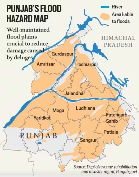
Punjab is witnessing flood for over a month now. The villages along the rivers Sutlej, Beas, Ravi and Ghaggar are the worst affected.
What is a flood plain?
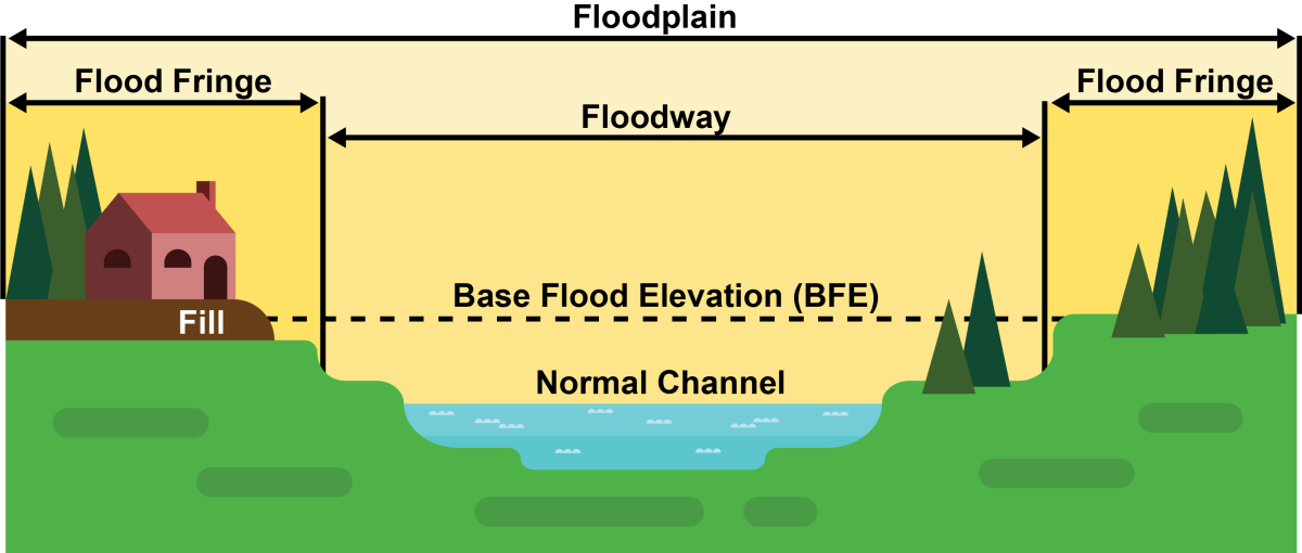
- A floodplain is a flat area of land next to a river or stream.
- It stretches from the banks of the river to the outer edges of the valley.
- The river expands and contracts naturally over seasons and in different years.
- A flood plain is an area adjacent to the river which normally gets flooded when the river swells.
- Floodway- It is the main channel of the river. It can sometimes be seasonal, meaning the channel is dry for part of the year.
- Flood fringe- It is present beyond the floodway. It extends from the outer banks of the floodway to the bluff lines of a river valley.
- Bluff lines, also called valley walls, mark the area where the valley floor begins to rise into bluffs.
- Formation-
- Erosion- It describes the process in which earth is worn away by the movement of a floodway.
- Aggradation - It describes the process in which earthen material increases as the floodway deposits sediment.
Why flood plain is important?
- Clear water- A healthy floodplain gives rivers the space to spread out and slow down, which allows such sediment to settle.
- It keeps water cleaner, protecting local drinking water and aquatic species like fish.
- Shading of streams by floodplain vegetation also helps regulate water temperature.
- Habitat- They are rich and biologically diverse environments that can support an abundance of plants, birds, fish, and other species on land and in the water.
- For example, Chinook salmon rely on floodplains for survival during the freshwater phase of their life cycle.
- Flood storage-Floodplains take on and store excess water in times of flood, releasing it slowly over land and into groundwater.
- Groundwater recharge-Rainwater travels deep into the ground of a floodplain to replenish groundwater supply.
- Groundwater travels slowly into rivers, lakes, and wetlands, regulating the availability of water during drier periods when people, plants, and animals need it most.
- Food- They have rich, fertile soils that have made them attractive to farmers for generations.
- Sustainable agricultural practices can help support key floodplain functions.
- Culture- Floodplains provide numerous recreational opportunities via lakes, rivers, etc.,
- The long history of settlement in floodplains as people have been drawn to the fertile land and abundant resources create a shared culture and sense of place in these locations.
- Example- Indus valley civilization situated near the river Indus.
How flood plain zoning is done?
- Identification- Experts find flood plain based on topographical features around rivers.
- For instance, flood plains often contain oxbow lakes basically abandoned meandering channels of the river, where it once flowed prior to changing its course.
- Demarcation of areas - It is done around rivers likely to be affected by floods of different magnitudes and frequencies, in order to specify the types of permissible developments there.
- This is done so that whenever floods do actually occur, the damage is minimal.
- Guidelines- As per guidelines on floodplain zoning by the National Disaster Management Authority,
- Defence installations, industries, and
- Public utilities like hospitals, electricity installations, water supply, telephone exchanges, aerodromes etc., should be located such that they are above the levels corresponding to a 100-year frequency or the maximum observed flood level.
What are the issues in Punjab?
- NGT - According to the National Green Tribunal (NGT), there should be no construction within 500 m area from the central lining of a river.
- However, despite NGT’s directions to the Government of Punjab, the state is yet to carry out flood plain zoning.
- The NGT even sent directions to the state’s chief secretary to personally monitor progress of zoning and ensure compliance of its directions.
- Encroachment-The flood plain areas of Sutlej, Beas, Ravi and Ghaggar have been encroached, making villages along these rivers perennially at risk of floods whenever they swell.
- Mismanagement- Encroachment and mismanagement of flood plains leading to non-suitable construction activity and concretization of flood plains.
- Non-suitable constructions- It pushes the flood further inland, increasing the area harmed and damage caused during floods.
- Concretisation- It takes far longer for floods to subside as the water simply does not drain.
- Affects soil- Floods is not good for floodplain and it affects the fertility and quality of the soil as well.
- Time constraints- The work on zoning of flood plains has started, but it will take time to be completed.
- Urban population-60% of the state is flood prone as four rivers Sutlej, Beas, Ravi and Ghaggar, flow through Punjab.
- The protection bundhs are made to protect the urban population from floods.
- Inadequate- Areas along the rivers in the districts of Ropar, Moga, Ferozepur etc., come under flood plains.
- It further highlights the risks that Punjab faces if it does not prepare adequately for floods.
What lies ahead?
- Flood plain zone regulation is adopted only by three states so far, States should stick to the regulation and formulate proper demarcation of floodplains.
- This would reduce the hazard and challenges posed by the flood in the long run.
References
Indian Express | Why flood plain zoning is important



