Mains: GS I – Salient features of World’s Physical Geography
Why in News?
Apart from anthropogenic factors which cause disasters, it is also important to understand the role of earth’s shifting forces.
What consists of Earth’s interior?
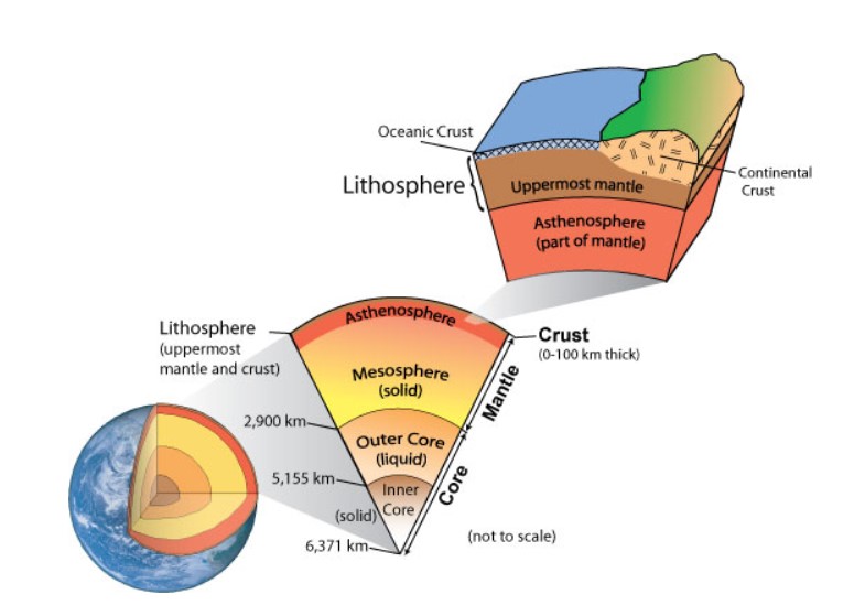
- The crust (5–70 km thick) – The uppermost layer where all forms of life and relief features are located.
- The mantle (extends to ~2,900 km depth) – It is divided into the upper mantle (~700 km) and lower mantle (700-2,900 km).
- The upper mantle has been further subdivided into
- lithosphere – Rigid, up to ~100 km
- Asthenosphere - Below lithosphere up to ~700 km depth.
- The asthenosphere is a ductile, semi-molten zone where convection currents move plates.
- The core (~2,900-6,371 km) – It extends to the Earth’s centre and is composed of iron and nickel.
How plates move?
- Rigid plates – The Earth’s surface is a mosaic of tectonic plates of various sizes.
- At present, there are seven major plates and a number of minor ones, all moving independently (floating) over a softer asthenosphere.
- Asthenosphere – The rigid masses (plates) are in continuous motion as they are floating over a semi-liquid surface below, known as the asthenosphere.
- These interactions lead to the formation of relief features such as mountains, plateaus, plains, etc.
- At the same time, they also cause destruction through tsunamis, volcanoes or earthquakes, as recently witnessed in Afghanistan.
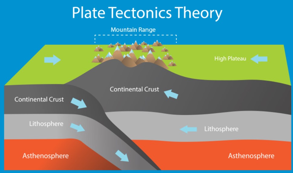
- Convergent boundaries – At Convergent boundaries, crust is destroyed as denser plate sinks under less denser plate.
- This process is called subduction.
- Oceanic Plates are denser compared to continental plates and can form the deepest Earth features called trenches.
- Divergent boundaries – At divergent boundaries, tectonic plates pull away from each other, giving rise to new crust.
- Transform boundaries – They are formed when two plates move horizontally and slide past one another.
What are forces shaping the Earth’s surface?
- Forces – The Earth’s surface and its relief features are the result of the forces working on lithospheric plates.
- Two types – Based on their origin, these forces are known as endogenetic (internal) or exogenetic (external) forces.
- Endogenetic forces – They are constructive, creating relief features by altering surface shape and size.
- Based on the intensity, endogenetic forces could be sudden or diastrophic.
- Sudden forces cause immediate effects such as seismic activities, tsunamis and volcanic eruptions, creating faults, rift valleys, volcanic mountains, etc.
- Exogenetic forces – These are destructive, continuously breaking down relief features through weathering, erosion, mass wasting, and deposition.
- Notably, there are theories that help understand these tectonic movements and forces causing changes to the Earth’s surface.
What are the different theories of evolution of earth?
- Continental drift theory – In 1912, German Meteorologist Alfred Wegener proposed the theory of ‘continental drift’.
- It revealed that the position of these continents is not stationary and continuously changing with varied rates over millions of years.
- This change is driven by forces like pole-fleeing force and the tidal force.
- While continental drifting was widely accepted, critics found these forces insufficient to move massive landmasses.
- Role of convection currents – In the 1930s, Arthur Holmes suggested that convection currents are operating in the entire mantle due to thermal differences of radioactive elements, causing continental drift.
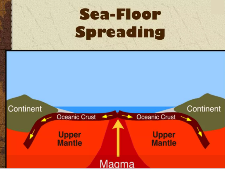
- It may be noted here that during World War II, ocean exploration also revealed complex seafloor relief features.
- Sea floor spreading – In the 1960s, Harry Hess, a US Navy officer during the war, gave the hypothesis of ‘sea-floor spreading’.
- Based on detailed mapping of the ocean floor and studies of paleomagnetic properties of rocks on either side of mid-oceanic ridges.
- Hess showed that new crust is formed at ridges and spreads outward.
- Plate tectonics theory – In 1967, Dan P. McKenzie, Robert L. Parker, and W. Jason Morgan independently integrated all the available information at that time and came up with the concept called ‘plate tectonics’.
- It efficiently explains the changes occurring on the Earth surface at present or that occurred in the past.
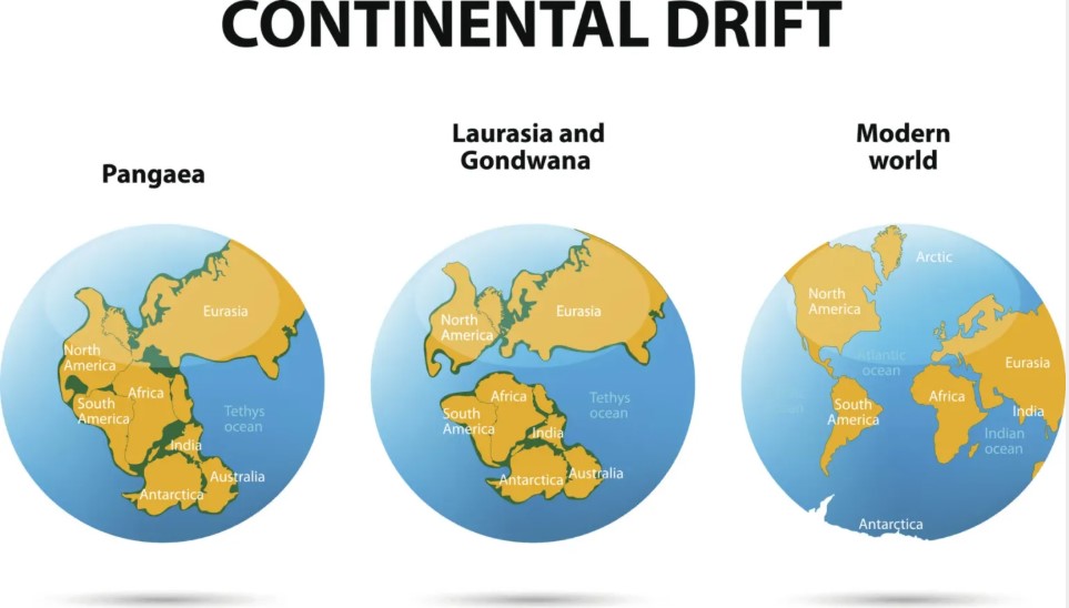
What was the supercontinent and its breaking?
- The Earth formed 4.6 billion years ago and has been continuously changing ever since.
- Pangea – Around 300-200 million years ago (mya), there was a supercontinent called Pangaea.
- Panthalassa – The Pangea was surrounded by a mega-ocean known as Panthalassa.
- Breaking of Pangea – Later, due to plate movements, Pangaea broke into two parts
- Lauratia – Present North America, Europe and Asia.
- Gondwanaland – Present South America, Africa, Peninsular India, Australia and Antarctica.
- Tethys Sea – The space between these two landmasses was filled with water, which was named the Tethys Sea.
- Cretaceous period – During the cretaceous period (145-66 mya), Peninsular India, Madagascar, Australia and Antarctica were broken and drifted away from Gondwanaland.
- South America and Africa were separated during the middle cretaceous period and the southern part of the present Atlantic Ocean formed.
- Late cretaceous period – The North Atlantic Ocean was formed with the separation and opposite movement of the North American continent from Eurasia and Greenland.
- Movement of Indian plate – The present Indian plate consists of Peninsular India, which was earlier part of the Australian continent.
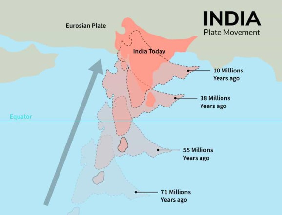
- It started moving northward around 71 million years ago, collided with the Eurasian plate, and created a continent-continent convergent boundary.
- Earlier, these two plates were separated by the Tethys Sea.
- Origin of Himalayas and Indian Ocean – The collision gave rise to the great Himalayan mountain ranges around 40 million years ago, and to the Indian Ocean.
Why there is a need to understand disaster preparedness with earth’s natural process?
- Dynamic nature of earth – Evidence of Paleomagnetism from sea-floor spreading shows that oceans and continents have never been stationary.
- Atlantic Ocean – It has divergent boundaries between the North American and Eurasian plates in the north, and between the South American and African plates in the south.
- The ocean is expanding (~2.5 cm/yr), increasing the distance of the Americas from Europe and Africa, while new oceanic crust is also continuously being formed.
- Pacific Ocean – Eastern and western coastal areas of the Pacific Ocean have active convergent boundaries and often witness active volcanic activities thus called the Pacific Ring of Fire.
- Due to this convergence, oceanic plates are subducting and the Pacific basin is continuously shrinking.
- Rise of Himalayas – The Himalayas continue to rise as the Indian plate moves northward at approximately 5 cm/yr.
- This also means that the region is tectonically active and poses seismic risks to the region.
- It threatens infrastructure and lives, particularly in the Himalayan belt, northeastern states, and densely populated Indo-Gangetic plains, as seen during the 2015 Nepal earthquake and more recent seismic events in Afghanistan.
- Hence, balancing disaster preparedness with resource utilisation should remain a national priority.
Reference
The Indian Express| Shifting Forces of Earth