Mains: GS III – Disaster Management
Recent, Nepal–China border disaster highlighted that natural disasters transcend political boundaries, impacting Nepal, China, and India and underscoring the interconnected vulnerability of the Himalayan region.
Geographical Features – The Himalayas constitute a transboundary ecological and hydrological system.
Rivers that originate in or traverse Nepal ultimately flow into India.
Glacial lakes, glaciers, landslides, and mountain valleys can generate hazards with impacts that extend well beyond the initial disaster location.
Limitations of Political Borders in Containing Transboundary Consequences
Water continues to flow downstream irrespective of established political borders.
Roads, bridges, and power infrastructure located in neighbouring countries are vulnerable to concurrent damage.
Tourism and pilgrimage routes create direct linkages between the three countries.
Disruptions occurring in one country can substantially affect trade, energy supply, and transportation networks in adjacent countries.
India is exposed to significant downstream risks as a result of the disaster.
Flood Risk – Floodwaters originating in Nepal may enter Indian territory via major river systems, including:
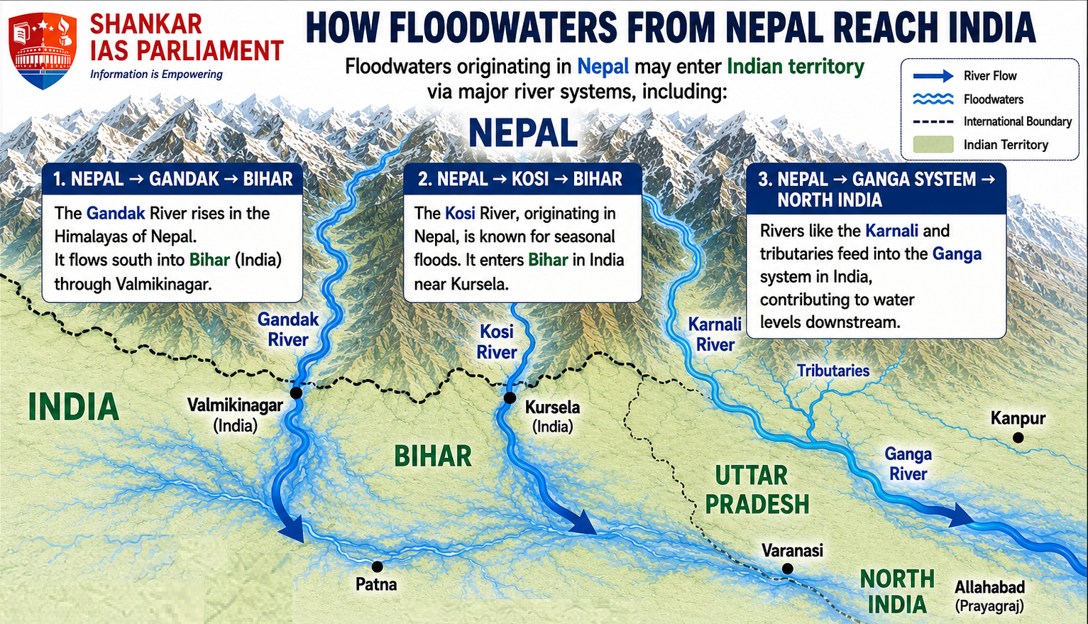
Vulnerable States – Immediately susceptible states such as Bihar and Uttar Pradesh were placed on red alert.
Border districts, including Maharajganj and Kushinagar, require increased monitoring during these events.
Humanitarian Consequences
Evacuation may be necessary for riverside communities.
Embankments are subjected to increased pressure.
Bridges and roads are at risk of damage.
Agricultural activities and livestock are vulnerable to adverse impacts.
India’s Response – India has implemented the following measures:
Emergency monitoring
Evacuation measures
National Disaster Response Force deployment
Humanitarian Assistance and Disaster Relief operations
Airborne delivery of relief material to Nepal
Trilateral Disaster Coordination Mechanism
India, China, and Nepal could jointly establish a dedicated mechanism called as Himalayan Disaster Coordination Mechanism.
This mechanism would focus exclusively on the following areas:
Early warning systems
Flood management
Landslide mitigation
Glacial hazard management
Search and rescue operations
Humanitarian assistance
Such an approach would enable disaster cooperation to remain distinct from broader geopolitical disputes.
Real-Time Data Sharing – Countries should exchange the following types of data as rapidly as possible:
River water levels
Rainfall data
Glacier movement
Glacial lake levels
Landslide warnings
Flood forecasts
Meteorological information
Proposed Data Sharing Models
Unidirectional flow – China to Nepal to India
Bidirectional flow – China, Nepal, and India exchange data mutually.
Timely dissemination of real-time information enables downstream communities to undertake critical evacuation measures.
Joint Early-Warning System
A Himalayan Transboundary Early Warning System should be developed utilizing the following technologies:
Satellite observation
Weather radar systems
River gauge networks
Seismic monitoring stations
Artificial intelligence-based flood forecasting
Remote sensing technologies
Automated alert dissemination
The primary objective is to ensure a streamlined process, such as Detection, prediction, alert dissemination, and evacuation.
Joint Search and Rescue Protocol – It is recommended that the three countries establish standardized protocols for the following areas:
Cross-border rescue
Helicopter operations
Medical evacuation
Emergency shelters
Rescue equipment
Missing-person coordination
Foreign tourist assistance
Such coordination is especially critical in remote Himalayan regions, where logistical challenges can impede timely rescue operations.
Protection of Critical Infrastructure – Infrastructure must be designed to address disaster risks that span multiple countries.
Priority Areas for Protection:
Hydropower plants
Bridges
Road networks
Border crossing facilities
Telecommunications infrastructure
Electricity transmission systems
River embankment structures
Airport facilities
Critical infrastructure requires disaster-resilient engineering rather than reliance on conventional construction methods.
Create Humanitarian Corridors – In the event of a major disaster, it is recommended that political and administrative restrictions be temporarily relaxed to facilitate the following:
Food
Medicine
Rescue teams
Emergency equipment
Fuel
Temporary shelters and rapid delivery of these resources to affected populations.
Joint Disaster Exercises – India, China, and Nepal should periodically conduct joint simulation exercises.
Objective – To address the following scenarios: Glacial collapse, flash flooding, border disruption, and downstream flooding.
Such exercises would evaluate the interoperability and effectiveness of their respective emergency response systems.
Flood Forecasting Systems in Bihar and Uttar Pradesh
Implementation of advanced hydrological models enables real-time flood prediction.
Integration with India Meteorological Department (IMD) rainfall data and satellite imagery enhances predictive accuracy.
Dissemination of flood warnings at the community level is achieved through mobile alerts and coordination with local administrative bodies.
Embankment Monitoring Mechanisms
Regular structural audits are conducted for embankments along the Ganga River and its tributaries.
Remote sensing technologies and drones are utilized to detect structural weaknesses.
Preventive reinforcement measures are implemented to reduce the risk of embankment breaches during peak monsoon periods.
Deployment of River-Level Sensors
Installation of Internet of Things (IoT)-based sensors enables continuous monitoring of river water levels.
Sensor data are transmitted to central flood control rooms to facilitate early warning dissemination.
This system improves the accuracy of flash flood and embankment breach predictions.
Development and Updating of Evacuation Plans
District-specific evacuation maps and designated safe routes are prepared.
Regular mock drills are conducted in collaboration with local communities.
Evacuation plans are updated annually based on the latest floodplain data and revised risk zone assessments.
Preparedness of the National Disaster Response Force (NDRF)
Specialised flood rescue battalions are stationed in districts identified as highly vulnerable.
These battalions are equipped with boats, drones, medical kits, and advanced communication equipment.
The NDRF conducts capacity-building programs in collaboration with State Disaster Response Forces (SDRFs).
A disaster originating in the Himalayas can quickly escalate into a transboundary crisis affecting Nepal, China, and India.
Consequently, these countries should transition from a perspective of “My territory, my disaster” to one of “Shared ecosystem, shared risk, shared responsibility.”



