0.2573
7667766266
x

Aravalli Range & Dust Storm in Northwest of India

iasparliament Logo
June 03, 2026

Prelims: Current events of national and international importance | Geography

Why in News?

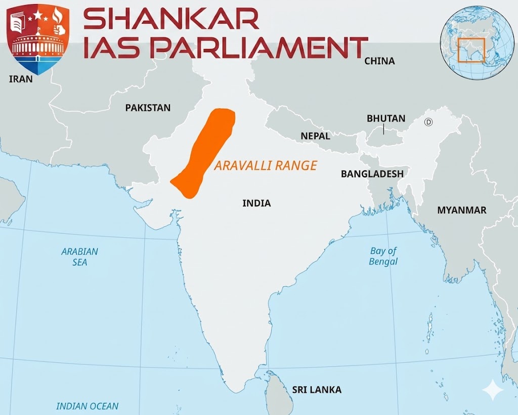
A massive dust storm swept through Rajasthan's Churu district recently, shrouding the sky in dust and turning day into night.

  • Origin - These pre-monsoon convective dust storms locally termed, Andhi are driven by intense solar heating during peak summer.
  • This extreme heating creates low-pressure centers over the Thar Desert, inducing highly unstable convective updrafts that lift loose, dry desert topsoil into the upper atmosphere.
  • Impacted Areas - Primarily Western and Northern Rajasthan (Churu, Bikaner, Jaisalmer, Sri Ganganagar).
  • Due to high-velocity winds, the dust plume regularly spills over into neighboring Haryana, Punjab, and the National Capital Region (NCR).

Aravalli range

Geography of Aravalli

  • The Aravallis are ancient fold mountains formed during the Proterozoic era The range trends in a Southwest to Northeast (SW-NE) direction.
  • Sharing states - It stretches across 4 states/UTs – Gujarat, Rajasthan Haryana, and Delhi.
  • Highest Peak - Guru Shikhar, located on Mount Abu in Rajasthan.
  • Rivers – Luni, Sabarmati, and Banas River.
  • Composition - The range is highly rich in metamorphic rocks such as quartzites, marbles, schists, and gneisses.
  • The Aravalli Range acting as a structural barrier between the arid Thar Desert and the fertile Indo-Gangetic Plains.
  • Physical Shield - The SW-NE alignment of the Aravalli hills physically blocks lower-tropospheric desert dust from moving eastward into the fertile agricultural belt of the Gangetic Plains.
  • Monsoon Interception - The range acts as a climatic divide.
  • While it runs parallel to the Arabian Sea branch of the Southwest Monsoon (causing Western Rajasthan to remain a rain-shadow zone), its eastern slopes intercept moisture, keeping the Gangetic basin fertile.
  • Degradation of the Aravalli Range- The protective capacity of the Aravallis is actively degrading due to human-induced factors.
    • Rocky Gap Expansion - The Aravalli Range is highly fragmented, featuring at least 28 documented natural gaps.
    • Massive illegal mining and hill flattening have widened these gaps, creating wind-conduits that allow Thar dust storms to easily breach into Delhi-NCR and Western UP.
    • Loss of Green Cover - Severe deforestation and unplanned urbanization along the foothills have destroyed the vegetative "green wall" that historically anchored shifting sand dunes.
    • Desertification - The weakening of this barrier accelerates the eastward creep of the Thar Desert, threatening the food security of the Indo-Gangetic plains by degrading soil quality and reducing visibility across Northern India.

Aravalli Range

Reference

The Indian Express | Churu dust storm

Login or Register to Post Comments
There are no reviews yet. Be the first one to review.

ARCHIVES

MONTH/YEARWISE ARCHIVES

sidetext
Free UPSC Interview Guidance Programme
sidetext