Mains: GSIII – Science and Technology
Why in News?
ISRO successfully launched NVS-03 in October, 2026, aboard GSLV-F18 from Sriharikota that aims to strengthen NavIC (Navigation with Indian Constellation), and revives the debate over its strategic importance compared to GPS.
What is NavIC?
- NavIC – Operational name of the Indian Regional Navigation Satellite System (IRNSS), developed by ISRO to provide independent Positioning, Navigation and Timing (PNT) services.
- Origin – Conceptualised after the U.S. denied GPS assistance to India during the 1999 Kargil conflict.
- Coverage – India and a region extending approximately 1,500 km beyond its boundaries.
- Services –
- Standard Position Service (SPS) – Available to civilian users.
- Restricted Service (RS) – Encrypted service intended for strategic users.
- Applications – Defence operations, transportation, maritime navigation, disaster management, surveying and precision agriculture.
What is NVS-03 and its Significance?
- Launch – October 30, 2026, aboard GSLV-F18 from Satish Dhawan Space Centre, Sriharikota.
- Satellite series – Third of five next-generation NVS satellites designed to strengthen NavIC.
- Payload – Operates in L1, L5 and S frequency bands.
- Indigenous technology – Equipped with an indigenous atomic clock alongside imported clocks.
- Significance –
- Strengthens India's independent PNT capabilities.
- Improves navigation coverage and service reliability.
- Supports civilian and strategic applications.
- NavIC constellation status –
- Before NVS-03, only three satellites (IRNSS-1B, IRNSS-1I and NVS-01) were providing PNT services.
- At least four operational satellites are required for basic positioning services.
- Of the nine functional satellites, four can broadcast navigation signals and five support one-way messaging.
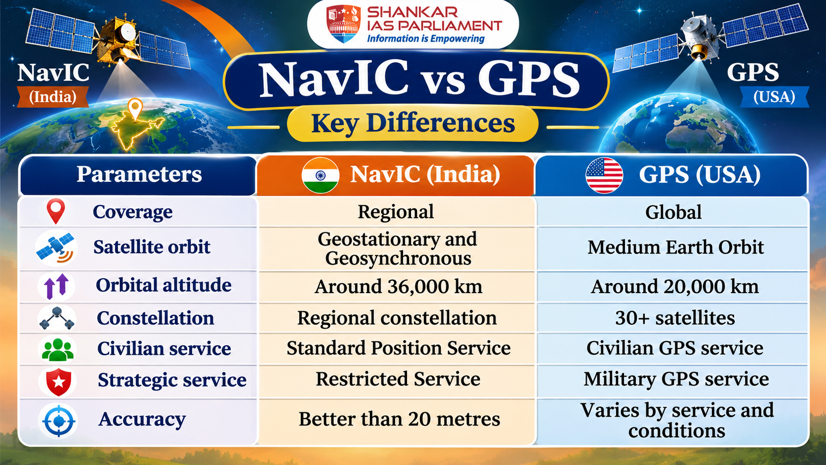
- Interoperability – NavIC signals are interoperable with GPS, Galileo (EU), GLONASS (Russia) and BeiDou (China).
- Timing accuracy – NavIC provides timing accuracy better than 50 nanoseconds, according to ISRO.
Why Does India Need an Independent Navigation System?
- Strategic Autonomy – Reduces dependence on foreign navigation systems during geopolitical tensions and military conflicts.
- National Security – Ensures reliable positioning and timing support for defence operations, missile guidance and military logistics.
- Technological Self-Reliance – Promotes indigenous satellite technology, atomic clocks and navigation infrastructure.
- Economic and Civilian Applications – Supports transportation, aviation, fisheries, maritime navigation, agriculture and location-based services.
- Disaster Management – Facilitates emergency communication, search and rescue operations and disaster response.
What are the Challenges in Strengthening NavIC?
- Limited Coverage – NavIC is regional and cannot replace GPS for global navigation requirements.
- Constellation Gaps – Earlier satellite failures reduced the number of operational navigation satellites.
- Technological Dependence – The use of imported atomic clocks highlights the need for greater indigenous capability.
- Limited Adoption – Wider integration into smartphones, vehicles and commercial navigation devices remains essential.
- Reliability – A stronger constellation is required to ensure uninterrupted and dependable services.
What is the Way Forward?
- Strengthen the Constellation – Complete the NVS series through the planned launch of NVS-04 and NVS-05 in 2027.
- Promote Indigenous Technology – Develop reliable indigenous atomic clocks and navigation components.
- Expand Civilian Adoption – Encourage NavIC integration into smartphones, automobiles, aviation and maritime systems.
- Improve Reliability – Maintain satellite redundancy and ensure continuity of navigation services.
- Promote Interoperability – Integrate NavIC with other GNSS systems for civilian applications while retaining independent strategic capabilities.
What lies ahead?
- NavIC should not be viewed as a complete replacement for GPS but as a strategic complement that strengthens India's technological sovereignty, national security and independent navigation capabilities.
Reference
The Hindu| Navic Vs. GPS