Recently, India has unveiled an updated seismic zonation map as part of the revised Earthquake Design Code by the Bureau of Indian Standards (BIS).
What is a seismic map?
Seismic map– It shows earthquake risk, highlighting areas prone to shaking, liquefaction, or landslides using color-coded zones to guide safe construction, urban planning, and emergency prep, based on data about faults, past quakes, and geology to predict shaking intensity over time.
Key Components & Meanings
Seismic Hazard Zones – Areas categorized by potential earthquake effects, from low to very high indicating increased risk.
Colour Coding – Different colours represent specific hazards (e.g., green for liquefaction risk, blue for landslides) or levels of ground shaking probability.
Isoseismal Lines – Contour lines on maps showing areas that experienced the same intensity of shaking (Modified Mercalli scale), useful for historical quakes.
Geological Data – Incorporates fault lines, soil types (which amplify shaking), and seismic wave behavior.
Application
Building Codes – Dictate how strong structures (hospitals, bridges, homes) must be built.
Land Use – Inform decisions on where to build critical infrastructure or develop residential areas.
Emergency Planning – Help authorities plan response and evacuation routes.
Risk Communication – Make complex geological data understandable for the public and developers.
What are the Key changes in the updated map?
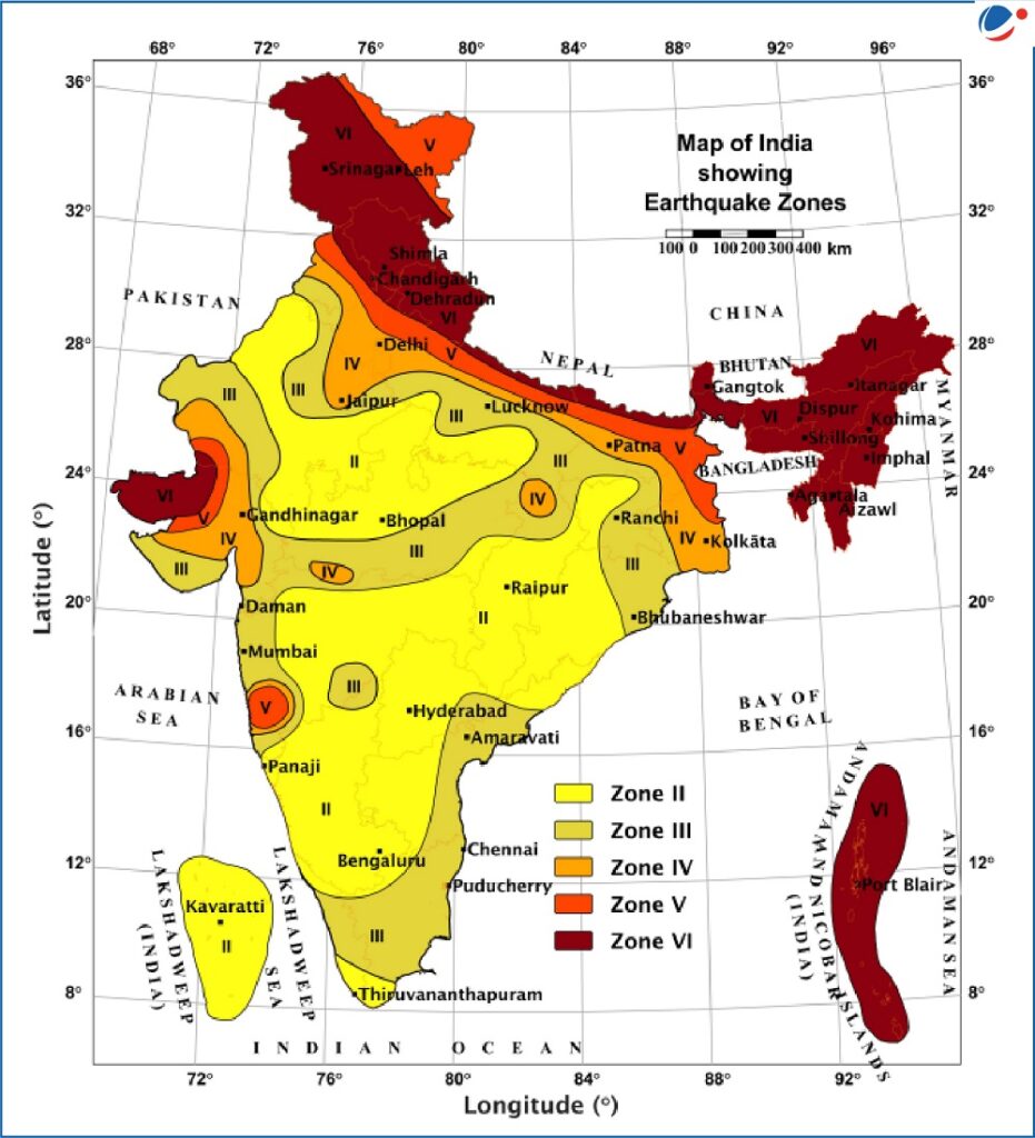
Previous map – 59% of India’s landmass was considered earthquake-prone and divided into four seismic zones based on the intensity of past events:
Zone II (low)
Zone III (moderate)
Zone IV (high)
Zone V (very high)
Zone V was the most seismically active region, while zone II was the least.
Updated map – It has added one more zone of the highest seismic-hazard category – Zone VI.
As a result, 61 % of India’s landmass now falls under moderate-to-high seismic hazard risk zones.
The Himalayan belt, which was earlier split across Zones IV and V, has now been put under a single highest risk Zone VI in view of high seismic risk across the entire region (from Jammu and Kashmir to Arunachal Pradesh).
In the long-overdue classification, which acknowledges the extensive tectonic vulnerability of the Himalayas, towns and cities that lie on the boundary of any two zones will now automatically be considered in the higher risk zone.
What is the rationale behind the update?
Basis – This revision is based on comprehensive data on faults, ground-shaking behaviour, tectonic movements, and underlying lithology (physical character of a rock or rock formation) of the vulnerable regions across the country.
Factors of safety – During any intense seismic events, the safety of the people depends mainly on two factors:
Structural Elements (SEs) – The load-bearing components of a building, like beams, columns, walls, etc.
Architectural Elements and Utilities (AEUs) – Non-structural elements held by SEs like glass windows, ceilings, lifts, air conditioning ducts, and other installations for services and utilities.
Conventional design – Traditionally earthquake-resistant design has largely focused on strengthening SEs.
However, damage to AEUs can also jeopardise the safety of the people and structures.
Any losses or damage to critical infrastructure, like government buildings, hospitals, schools, commercial complexes, malls, convention centres, and milk and food supply stores, can lead to major socio-economic consequences.
Revised design – The revised Earthquake Design Code, 2025, seeks to address this gap by laying down standards for the design of SEs and protection of AEUs.
These provisions are expected to reduce the damage to both SEs and AEUs during earthquake effects like ground shaking.
Achieving SDG – These revisions will help towards achieving two crucial United Nations Sustainable Development Goals (SDGs):
SDG 9 (Industry, innovation and infrastructure) – By building resilient infrastructure, promoting inclusive and sustainable industrialisation, and fostering innovation.
SDG 11 (Sustainable cities and communities) – By enhancing the safety, resilience, and sustainability of cities and human settlements.
What are the seismic vulnerabilities of India?
Dynamic Indian plate – The Indian Plate is still moving towards the Eurasian Plate at nearly 5 cm/year.
This ongoing collision led to the formation of the Himalayas – a geologically young region, meaning the rocks are still adjusting, folding and breaking, making the mountains unstable.
The Himalayas have not yet attained isostatic equilibrium (or gravitational equilibrium) and continue to rise.
This makes the region vulnerable to frequent earthquakes of varying intensities.
Major fault system – Beneath the Himalayan ranges lie three major fault systems:
Main Central Thrust (MCT) – Between the Greater and the Lesser/Middle Himalayas
Main Boundary Thrust (MBT)- Between the Lesser Himalayas and Outer Himalayas (Shiwaliks)
Main Frontal Thrust (MFT) or Himalayan Frontal Fault (HFF) – Between the Outer Himalayas and Northern Indian Plains
The HFF is the southernmost fault and has densely populated foothills.
The recent seismic hazard update has been cautious about the potential southward propagation of rupture along this fault, which could extend the hazards into areas such as Dehradun.
Devastating earthquake experiences – According to the National Disaster Management Authority (NDMA), India has experienced 10 major earthquakes over the last 15 years, resulting in over 20,000 casualties.
Historically, India, particularly the Himalayan belt, has been vulnerable to high-magnitude seismic events, sometimes exceeding 8.0.
Major devastating Earthquakes – Four particularly devastating earthquakes happened within a span of 50-55 years, claiming thousands of lives and causing severe damage to properties:
1897 Shillong earthquake (M 8.7)
1905 Kangra earthquake (M 8.0)
1934 Bihar-Nepal earthquake (M 8.3)
1950 Assam-Tibet earthquake (M 8.6)
More recently, the 2001 Bhuj earthquake (M 7.9) claimed 12,932 lives and devastated 890 villages.
India’s high seismic vulnerabilities is further evident in the fact that it recorded 159 earthquakes within four months between November 2024 and February 2025.
How the revised map seeks to minimise seismic risk?
Exposure window concept – To minimise seismic risk, the revised map introduced the concept of ‘exposure window’.
It considers population density, concentration of infrastructure, urban expansion patterns, and socio-economic vulnerability.
This has been introduced using the Probabilistic Exposure and Multi-Hazard Assessment (PEMA) method.
Consideration of multiple factors – While readjusting the zones, the aim was to consider both physical and geological factors as well as the potential human and economic impacts.
This is particularly important for densely populated cities, where even moderate intensity earthquakes can also cause significant damage.
Conformity with the norms – The BIS has urged that all new infrastructure projects and structures be constructed in accordance with the revised guidelines.
Revision of codes – The Himalayan states, which are now reclassified into Zone VI, will be required to revise building codes, infrastructure design norms, and long-term urban planning frameworks.
Mandatory seismic audits and retrofitting of vulnerable infrastructure will be essential for future preparedness.
What lies ahead?
Challenges posed by earthquakes as a disaster are unique, as their location, time, and magnitude still cannot be predicted with precision.
This necessitates a stronger emphasis on preparedness and mitigation measures to minimise losses.
There is a need to preserve traditional construction practices and integrate the safety provisions, wherever required, to enhance their resilience.
There is also an urgent need to retrofit critical older structures of cultural, social, and historical importance to ensure their resilience.
The Prime Minister’s 10-Point Agenda for Disaster Risk Reduction (DRR) also emphasises leveraging technology to enhance the efficiency of disaster risk management efforts.
Accordingly, efforts towards improving infrastructure, developing early warning systems, and enforcing safety standards and guidelines are crucial to ensuring safety during future earthquakes.