Building a Safer, Smarter Network
The Ministry of Ports, Shipping and Waterways highlighted India’s efforts to improve inland waterway navigation through hydrographic surveys, navigation aids, riverine lighthouses and digital platforms.
Importance of Inland Waterways
- Cost-effective transport: Water transport costs nearly one-third of road transport and half of rail transport per tonne of freight, while generating fewer carbon emissions.
- Network: India has 111 National Waterways spanning 20,187 km across 23 States and 4 Union Territories, of which 32 are operational.
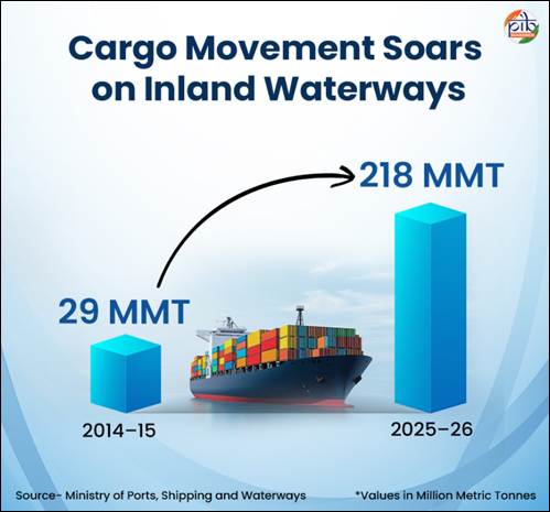
- Growing traffic: Cargo movement increased from 29 MMT in 2014–15 to 218 MMT in 2025–26, achieving a 20.13% CAGR and surpassing the 200 MMT target under Maritime India Vision 2030.
Hydrographic Surveys and Fairway Maintenance
- Hydrographic surveys: Conducted by the Inland Waterways Authority of India (IWAI) to assess river depth, bed profiles, shoals, flow patterns and changes affecting navigability.
- Types: Thalweg surveys identify the deepest navigable channel, while terminal and jetty surveys assess water depth and approach conditions.
- Dredging: Removal of sediments to maintain navigable channels.
- Least Available Depth (LAD): Indicates the minimum available water depth and helps determine vessel draft, cargo capacity and seasonal navigation schedules.
- As of September 2026, regular thalweg surveys covered 22 National Waterways, with weekly, fortnightly or monthly monitoring.
Aids to Navigation (AtoN)
- Recognised under the Marine Aids to Navigation Act, 2021, these include buoys, channel markers, radar beacons, lighthouses and beacon lamp posts.
- The Directorate General of Lighthouses and Lightships (DGLL) manages coastal navigation aids, while IWAI maintains aids across National Waterways.
- Example: National Waterway-3 in Kerala has 312 solar-powered lighted FRP buoys and 17 beacon lamp posts to support 24×7 navigation.
Riverine Lighthouses on the Brahmaputra
- India announced its first four riverine lighthouses in March 2026 at Pandu, Bogibeel, Silghat and Biswanath Ghat under a ₹74-crore project.
- The lighthouses will be solar-powered, rise 20 metres above ground and provide geographical visibility up to 14 nautical miles.
- Located on National Waterway-2, which connects Dhubri to Sadiya over 891 km, they will improve night navigation, safety and tourism.
- Cargo movement on NW-2 increased from 0.90 MMT in 2024–25 to 1.29 MMT in 2025–26.
Digital Navigation Systems
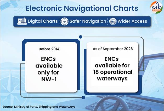
- Electronic Navigational Charts (ENCs): Prepared for 18 operational and tidal waterways and made available through PANI and IWAI Vessel Tracker.
- PANI (Portal for Asset and Navigation Information): Provides waterway, infrastructure, jetty connectivity and emergency-service information.
- IWAI Vessel Tracker: Supports real-time vessel tracking, route updates and depth information.
- Naudarshika: Launched in 2025 to support river traffic management using real-time LAD information.
- River Information Services (RIS): Integrates vessel tracking, weather sensors and communication systems. On NW-1 (Ganga), it covers three stretches with four control stations and 13 base stations.
Conclusion
Integrating hydrographic surveys, navigation infrastructure and digital technologies can make India’s inland waterways safer, more efficient and environmentally sustainable, while strengthening cargo connectivity and regional economic development.



