Mains: GS-III – Science & Technology | Space Technology
Why in news?
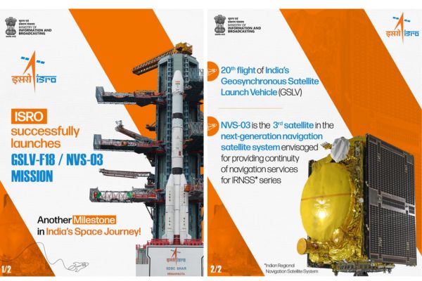
Recently, ISRO has successfully launched the NVS-03 — its third new-generation navigation satellite, which is likely to restore the functioning of India’s satellite-based positioning system, NavIC.
What does NVS-03 carry, and what is the significance of its payloads?
- NVS-03 – It is a part of ISRO’s second-generation navigation satellite series, launched to replenish and modernise the Navigation with Indian Constellation (NavIC), India’s regional satellite navigation system.
Key features
- Launched by – Indian Space Research Organisation (ISRO).
- Launch Vehicle – Geosynchronous Satellite Launch Vehicle (GSLV-F18).
- Mass & Orbit – Weighed 2,250 kg and was precisely injected into a Geosynchronous Transfer Orbit (GTO).
- Indigenous atomic clocks – NVS satellites carry at least one indigenously developed rubidium atomic clock.
- Developed by – ISRO’s Space Applications Centre.
- They are intended to replace the imported rubidium clocks manufactured by Swiss company SpectraTime that were used in the first generation of Indian Regional Navigation Satellite System (IRNSS) satellites.
Atomic clocks are central to satellite navigation. They provide highly precise timing signals that allow receivers on the ground to calculate their position by measuring the time taken by signals to travel from satellites. Even a small error in timing can translate into a significant error in determining location.
- Support for the L1 frequency band – Unlike earlier NavIC satellites, the NVS series supports the L1 frequency band, a globally used navigation frequency.
- This enables wider compatibility with smartphones and navigation devices and allows users to access Indian Standard Time services more easily.
- Improved compatibility – The addition of the L1 band is expected to improve interoperability with other satellite navigation systems, particularly the U.S.’s Global Positioning System (GPS), improving the reliability and usability of navigation services across different platforms.
What is NavIC and what was India hoping to achieve with it?
- NavIC – Navigation with Indian Constellation, is the operational name for the Indian Regional Navigation Satellite System (IRNSS).
- Coverage & Capabilities – A seven-satellite constellation that covers the Indian subcontinent and a region up to 1,500 km around it, NavIC is a regional satellite-based navigation system similar to the US’s Global Positioning System (GPS).
- Origin – India began developing NavIC following the 1999 Kargil War, when the U.S. reportedly clamped down on GPS data access.
- The episode exposed the strategic limitations of depending on a foreign-controlled satellite navigation system, particularly during a conflict.
- Regional navigation system – The first-generation IRNSS satellites were launched between 2013 and 2018 and were designed to provide positioning, navigation and timing (PNT) services over India to an area extending approximately 1,500 km beyond its boundaries.
- Unlike GPS, which has global coverage, NavIC was conceived primarily as a regional system.
- Civilian applications – It supports various civilian services, including navigation, transportation, disaster management, telecommunications and the synchronisation of clocks used in financial and other services.
- Dual signal for strategic purposes – Satellite navigation systems generally provide two categories of signals
- An open signal for civilian users and
- A restricted signal intended for authorised users, including the armed forces.
- The latter offers greater accuracy, with the restricted signal able to increase accuracy roughly tenfold.
- For the armed forces, an indigenous navigation system offers a degree of operational independence.
- Depending entirely on another country’s satellite infrastructure carries risks, particularly during hostilities, when signals could potentially be disrupted, degraded or manipulated.
- Strategic importance – NavIC was therefore intended not merely as an alternative to GPS for civilian users but as a strategic asset that would give India greater control over its positioning and timing requirements.
- However, even with NVS-03, it will be a while before these loftier goals are practically achieved.
Why is NavIC not functioning as intended?
- Failure of atomic clocks – It is the immediate problem aboard several first-generation satellites and the inability to replenish the constellation at the required pace, weakening the navigation network.
- Failure of 1st generation satellites – Of the satellites launched under the original IRNSS programme, several have either been decommissioned, failed to reach their intended orbits or suffered failures of their onboard clocks.
- Worsening situation – In July 2025, ISRO disclosed through a Right to Information response that five satellites were completely defunct, with all three clocks aboard each no longer functioning.
- The situation deteriorated further in March 2026, when the last functioning atomic clock aboard IRNSS-1F stopped working.
- The satellite, launched in March 2016, had completed its designed mission life of 10 years just three days earlier.
- This left only three satellites capable of providing Positioning, Navigation and Timing (PNT) service, whereas at least four operational satellites are necessary for NavIC to provide positioning and navigation services.
- NVS-02 setback – There was also a setback in January 2025, when ISRO successfully placed NVS-02 in geosynchronous transfer orbit, but the satellite’s thrusters failed to move it into its intended final orbit.
- Consequently, it could not become an operational replacement for the ageing satellites.
What corrective measures is ISRO attempting?
- Replenishing the NavIC constellation – The immediate priority is to replenish the constellation through the second-generation NVS satellites.
- Deployment of the NVS series – NVS-01, launched in May 2023, was successfully placed in orbit and carries an indigenously developed rubidium atomic clock.
- NVS-02 was the second satellite in this series, but its failure to reach the intended final orbit delayed the subsequent launches.
- NVS-03, followed by NVS-04 and NVS-05 - all to be launched by Dec ‘26 – is expected to help restore the constellation.
- Boost atomic clock reliability – ISRO has also sought to address the reliability of its atomic clocks, and moving away from imported clocks towards indigenous rubidium clocks is a key part of this effort.
- Increasing redundancy – ISRO has proposed increasing the number of atomic clocks aboard each satellite from the earlier three to five, providing additional redundancy should individual clocks fail.
- Challenges in indigenous development – The indigenously developed clocks have also faced procurement challenges.
- The transition to domestic manufacturing does not automatically ensure a dependable supply of flight-ready equipment.
- Institutional challenges – ISRO continues to function as both the designer and operator of NavIC and, unlike the U.S. GPS Directorate or the European Union Agency for the Space Programme, lacks a dedicated counterpart to manage its navigation constellation.
- The absence of a national space law and the competing demands on ISRO’s resources have also been identified as constraints.
- The agency must simultaneously pursue human spaceflight, Earth-observation missions, new launch vehicles and research and development, leaving it stretched.
How do the recent launch failures complicate the NVS-03 mission?
- The NVS-03 launch comes against the backdrop of an unusually difficult period for ISRO.
- Back-to-back PSLV failures – Two successive failures of the Polar Satellite Launch Vehicle (PSLV), in May 2025 and January 2026.
- The PSLV-C61 mission, carrying the EOS-09 satellite, failed on May 18, 2025.
- The PSLV-C62 mission, carrying the N1 satellite, failed on January 12, 2026.
- In both instances, the rocket encountered anomalies during its third stage of operation.
- Pause of launch – These failures have forced the space agency to pause launches while a Failure Analysis Committee investigated the causes and recommended corrective measures.
- Concerns over rocket reliability – Although the PSLV and Geosynchronous Satellite Launch Vehicle (GSLV) are different rocket families, they share certain design features, including aspects of their first-stage solid motor lineage, avionics, guidance systems and manufacturing infrastructure.
- Measures taken – The government has said that the causes of the failures have been identified and resolved.
- However, it has declined to make the National Level Expert Committee’s findings public, making it difficult to independently assess the corrective measures.
- Growing launch backlog – Of the seven major missions since December 25 that the Department of Space had scheduled for completion, only two — the commercial LVM3-M6 mission carrying the BlueBird Block-2 satellite — were successfully completed and were launched on December 24, 2025.
- The failures include the PSLV-C62 launch in January, which failed to place its payload in the intended trajectory.
- The GSLV-F17 rocket that placed the EOS-05 Earth-observation satellite in orbit is the agency’s only successful orbital launch of 2026 ahead of the NVS-03 mission.
How does NavIC compare with other navigation systems?
- NavIC – NavIC is India's indigenous satellite navigation system and is unique because it is designed as a regional navigation system, whereas most major navigation networks provide worldwide coverage.
India is the only country with a regional navigation system.
- Japan – Japan, whose four-satellite Quasi-Zenith Satellite System augments GPS signals in the Asia-Oceania region, has all its satellites in high orbits just like NavIC.
- 4 global navigation systems –
- GPS (USA) – Most popular one, uses around 32 satellites,
- GLONASS (Russia) – GLObalnaya NAvigatsionnaya Sputnikovaya Sistema, uses 24 satellites.
- Galileo (European Union) – 27 satellites, and the
- Beidou (China) – 30 satellites.
- Differences in satellite orbits – Other than Beidou, all the constellations use satellites in middle-earth orbit (at an altitude between 19,000 and 24,000 km).
- BeiDou's hybrid approach – Beidou uses a combination of satellites in middle earth as well as higher altitudes, enabling broader and more flexible coverage.
References
- The Hindu | Why is ISRO’s NVS-03 satellite launch crucial?
- Indian Express | How ISRO’s new satellite could restore India’s regional GPS alternative