Mains: GS I – Geography
Recent Devastating floods in Nepal’s Bhotekoshi–Trishuli river have claimed over 350 lives, underscoring the Himalayan region’s acute vulnerability to climate‑induced disasters.
Transboundary Dynamic Ecosystem – Himalayan rivers cross several national borders, so disasters in Nepal, Tibet, or Bhutan often have downstream effects in India.
Effective management of shared river systems requires real-time information sharing and coordinated disaster response among affected countries.
Geologically Young and Fragile Mountain Systems – The Himalayas are classified as young fold mountains characterised by unstable slopes.
Elevated rates of erosion and persistent slope instability significantly increase the region's vulnerability to landslides.
High Seismic Vulnerability – The Himalaya is situated along the active tectonic collision zone between the Indian and Eurasian plates.
Seismic activity frequently triggers landslides, avalanches, and breaches of glacial lakes.
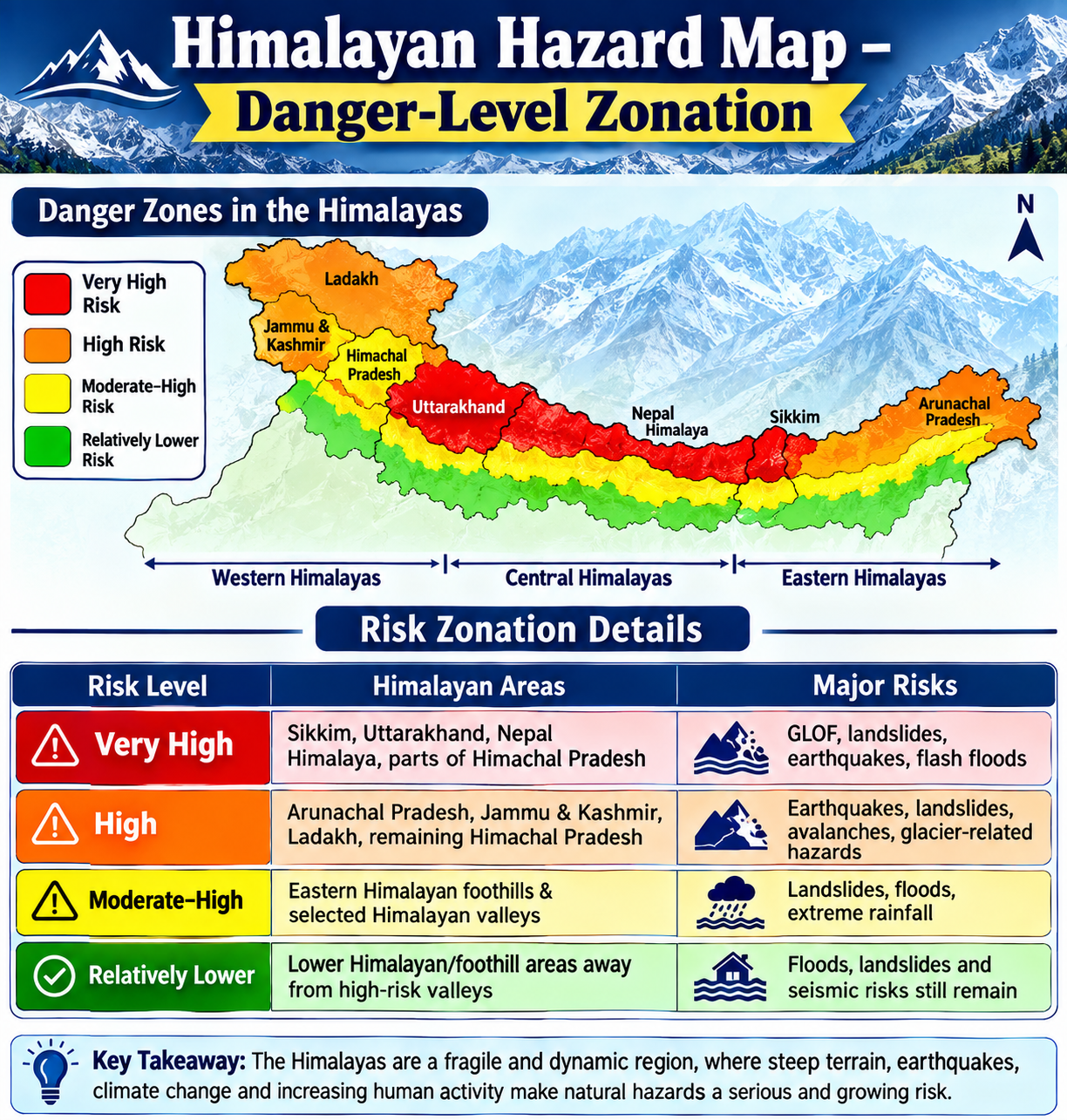
Rapid Glacier and Cryosphere Changes – Increasing temperatures contribute to glacier retreat and heightened instability within the cryosphere.
The formation and expansion of glacial lakes elevate the risk of glacial lake outburst floods (GLOFs).
Extreme Rainfall Events – Short-duration, high-intensity rainfall events frequently trigger flash floods and landslides.
Steep River Gradients – Rivers in the region descend rapidly through narrow valleys.
Water, rocks, ice, and debris accumulate significant destructive energy as they move through these steep gradients.
Plate Collision – The collision of the Indian Plate subducting beneath the Eurasian Plate results in significant stress accumulation, which frequently leads to high-magnitude earthquakes.
Locked Faults – The release of accumulated pressure along locked faults can trigger massive earthquakes.
Unregulated Construction – Unregulated construction activities, including road building, dam construction, deforestation, and increased tourism, place additional stress on the region's fragile terrain.
Carrying Capacity Failures – Failures to respect the carrying capacity, such as overcrowded towns and unchecked infrastructure development, further amplify environmental and seismic risks.
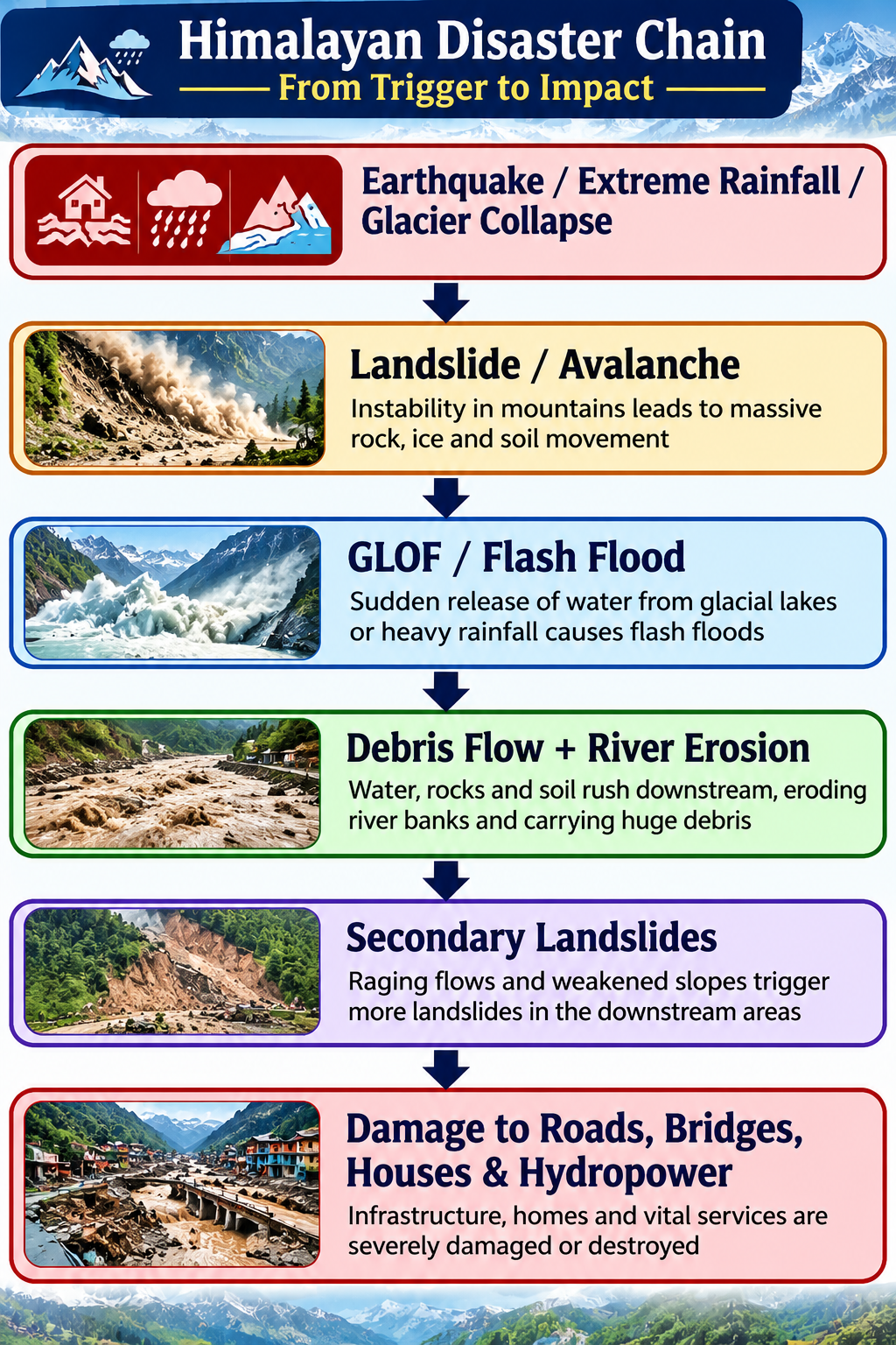
Cascading Multi-Hazard Risks - A single trigger can produce multiple hazards:
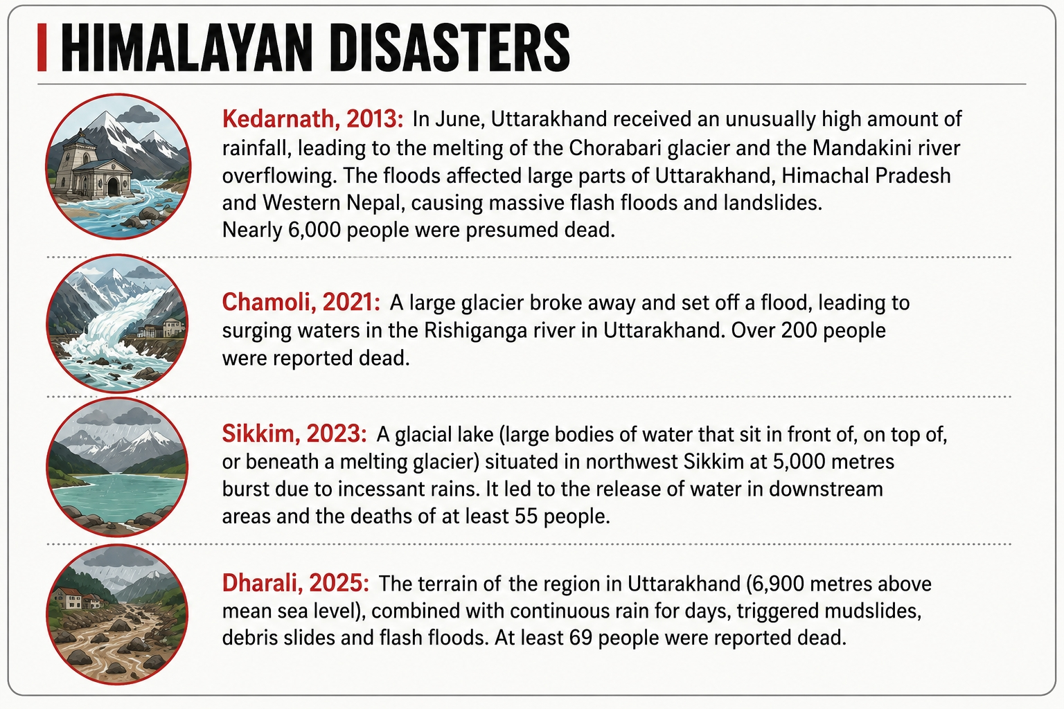
National GLOF Risk Mitigation Programme (NGRMP) – The National Disaster Management Authority (NDMA) initiated this programme following the Sikkim disaster.
Objective – To establish early-warning systems for glacial lakes identified as high risk.
It targets 195 glacial lakes located in the following regions:
Sikkim
Uttarakhand
Himachal Pradesh
Arunachal Pradesh
Jammu & Kashmir
Ladakh
The total programme outlay is ₹150 crore.
Additional Risk Mitigation Measures
Glaciers and glacial lakes are monitored using remote sensing and satellite technology.
Disaster management planning is conducted under the guidance of the NDMA and State Disaster Management Authorities.
Early-warning and emergency communication systems are being developed.
Hazard and vulnerability mapping is undertaken to identify at-risk areas.
Preparedness for search, rescue, and evacuation operations is being enhanced.
Inadequate Early-Warning Coverage – Numerous vulnerable glacial lakes lack real-time early warning systems.
Limited Scientific Data – Continuous monitoring is hindered by challenging terrain and extreme weather conditions.
Unplanned Construction – The development of roads, hotels, hydropower projects, and settlements frequently increases exposure to hazards in fragile valleys.
Climate Change Uncertainty – Alterations in temperature and precipitation patterns reduce the reliability of historical risk assessments.
Transboundary Coordination – Although Himalayan hazards are transboundary, real-time data sharing and coordinated warning mechanisms are still limited.
Difficult Terrain – Limited accessibility frequently delays rescue operations, relief efforts, and post-disaster communication.
Development–Ecology Conflict – Infrastructure and energy demands must be balanced with the carrying capacity of fragile mountain ecosystems.
Universal Early-Warning Coverage – Deploy real-time sensors and automated warning systems in areas surrounding high-risk glacial lakes and vulnerable valleys.
Strengthen Himalayan Risk Mapping – Develop micro-level hazard maps that address glacial lake outburst floods (GLOFs), landslides, earthquakes, avalanches, and flash floods.
Regulate Construction – Mandate carrying-capacity assessments and implement strict land-use zoning prior to infrastructure approval.
Climate-Resilient Infrastructure – Ensure that roads, bridges, hydropower projects, and settlements are designed in accordance with disaster-resilient standards specific to mountainous regions.
Strengthen Transboundary Cooperation – Establish real-time information-sharing mechanisms among India, Nepal, Bhutan, and China for monitoring floods, glacial activity, and earthquakes.
Community-Based Disaster Preparedness – Provide training to local communities in the following areas:
Early evacuation
Emergency communication
First response
Safe evacuation routes
Ecosystem-Based Disaster Risk Reduction – Conserve forests, wetlands, and natural drainage channels to enhance ecosystem-based disaster risk reduction.
Prohibit excessive slope cutting and riverbed encroachment to maintain natural landscape stability.
Integrated Himalayan Disaster Observatory – Integrate satellite data, ground sensors, weather forecasts, seismic monitoring, and artificial intelligence-based risk modelling to enable predictive disaster management.
The Nepal floods illustrate that disasters in the Himalayan region are not isolated incidents but represent cascading multi-hazard phenomena.
The interaction of climate change with geological fragility, rapid infrastructure development, and increasing population pressure significantly amplifies associated risks.
Consequently, India should transition from a reactive, relief-based approach to an anticipatory and ecosystem-sensitive disaster management strategy.



