Galapagos Islands
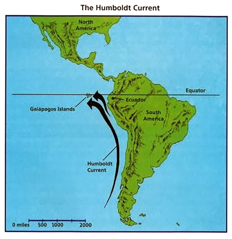
- The Galapagos Islands are located in the Pacific Ocean around 1,000 km away from the South American continent.
- Ecuador made a part of the Galapagos a wildlife sanctuary in 1935, and the sanctuary became the Galapagos National Park in 1959.
- In 1978, the islands became UNESCO’s first World Heritage Site.
- It contains aquatic species such as manta rays and sharks which have been endangered by commercial fishing.
- It also hosts a wide array of aquatic wildlife, including marine iguanas, fur seals, waved albatrosses and giant tortoises 'Galápagos'.
- Galapagos area is natural habitat of critically endangered scalloped hammerhead sharks.
- Recently, Ecuador has expressed an official discomfort over the sighting of Chinese fishing vessels near the Galapagos archipelago.
- Chinese fishing ships are frequent in Ecuador's waters during august month of the year as the cold Humboldt Current brings in nutrients that lead to a high congregation of hammerhead sharks.
Humboldt Current
- The Humboldt Current, also called the Peru Current, is a cold, low-salinity ocean current that flows north along the western coast of South America.
- The Humboldt Current is a highly productive ecosystem.
- It accounts for roughly 18-20% of the total worldwide marine fish catch.
BeiDou
- China’s administration has officially commissioned BeiDou Navigation Satellite System constellation.
- It was initiated in 1994.
- It aims to integrate its application in different sectors, including fishery, agriculture, special care, mass-market applications, forestry and public security.
- It now offers services including accurate positioning, navigation and timing as well as short message communication.
- BeiDou uses a network of satellites and can provide positional accuracies of under 10 meters, whereas GPS provides positioning accuracies of under 2.2 meters.
- Chinese military has employed Beidou-guided conventional strike weapons to counter a US intervention in a potential contingency, if access to GPS is denied.
- Navigation Systems of other countries are as follows
- NAVIC – India
- GPS - USA
- GLONASS - Russia
- GALILEO – EU
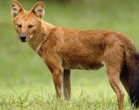
Dhole
- Dhole is also known as Asian wild dog, Asiatic wild dog, Indian wild dog, whistling dog, red dog, and mountain wolf.
- Besides the tiger, the dhole is the only large carnivore in India that is under the IUCN’s ‘endangered’ category.
- It play an important role as apex predators in forest ecosystems.
- A research paper on conserving the endangered dhole was published in Mammal Review.
Highlights
- Karnataka, Maharashtra and Madhya Pradesh rank high in the conservation of the endangered dhole in India.
- On the other hand, Arunachal Pradesh, Chhattisgarh, Odisha, Telangana and Goa will need to increase reduce the ease of granting forest clearances for infrastructure projects.
- Improving habitat conditions and prey densities in the Eastern Ghats of Andhra Pradesh, Telangana and Odisha would “strengthen the link” between dhole populations in the Western Ghats and central India.
- India has the highest number of dholes in the world, but India don’t have targeted management plans for scientific monitoring of the species.
Medicinal and Aromatic Plants Genetic Resources (MAPGRs)
- National Medicinal Plants Board (NMPB) and ICAR-National Bureau of Plant Genetic Resources (NBPGR) have entered into a MoU to conserve the Medicinal and Aromatic Plants Genetic Resources (MAPGRs).
- The conservation will be done in long-term storage module in the National Gene bank and/or at Regional Station for medium term storage module.
- The authorized institute NMPB and the ICAR-NBPGR on behalf of the ICAR would develop detailed modalities for seed storage of MAPGRs.
National Medicinal Plants Board (NMPB)
- It was set up in 2000.
- It is working under Ministry of AYUSH.
- Mandate – To develop appropriate mechanism for coordination for overall growth of medicinal plants sector both at the Central /State and International level.
National Bureau of Plant Genetic Resources
- It was established in 1977.
- It is under Department of Agricultural Research and Education.
- It plays a pivotal role in the improvement of various crop plants and diversification and development of agriculture through germplasm introduction.
Agatti Island
- It is in the UT of Lakshadweep.
- It is at a distance of 459 km (248 nautical miles) from Kochi and is located to the west of Kavaratti Island.
- The lagoon area of this island is habitat of coral growth and multicolored coral fishes in the lagoons.
- Fishing is the most important industry which is perhaps the only island besides Minicoy getting surplus fish.
- Next to fishing, coir (coconut fibre) and copra (dried meat or kernel of the coconut) are the main industries.
- Recently, the southern bench of the National Green Tribunal (NGT) has granted an interim stay on felling of coconut trees on Agatti Island in Lakshadweep.
- The tree-felling is also violating the Union Territory’s (UT) Integrated Island Management Plan (IIMP).
- IIMP was formulated on the basis of a report submitted by the Supreme Court-appointed Expert Committee, headed by Justice R.V. Raveendran.
- It includes holistic island development plans prepared by the National Centre for Sustainable Coastal Management (NCSCM) for implementation by coastal States/ UTs.
Yellow Fever
- Yellow fever is caused by a virus that is spread by the Aedes aegypti mosquito.
- These mosquitoes thrive in and near human habitations where they breed in even the cleanest water.
- It is endemic in 34 countries in the sub-Saharan African region, despite the existence of a vaccine for the disease.
- There are three transmission ‘cycles’ for the disease in Africa - Urban, zoonotic and intermediate.
- The urban cycle mediated by Aedes aegypti mosquitoes is responsible for explosive outbreaks.
- According to new study the disease is projected to shift to Central and East Africa from West Africa by 2050.
- The study also highlighted that vaccination is the most important and effective measure against yellow fever.
Source: The Hindu, Indian Express, News on AIR
