What is the issue?
- Following the Pulwama terror attack, the civilian traffic movement is said to be restricted during the movement of convoys of security forces.
- It is essential, in this context, to understand the challenges involved in the Jammu-Srinagar-Uri national highway.
What and how are the key stretches in the highway?
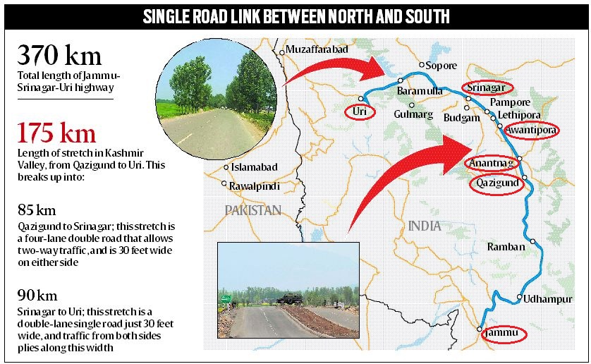
- The Jammu-Srinagar-Uri national highway is the only road link between Jammu and Kashmir. It runs for nearly 370 km.
- The length includes 175 km in the Valley, from Qazigund in South Kashmir to Uri in North Kashmir.
- It passes through Anantnag, Pulwama, Srinagar and Baramulla.
- It is this stretch of the highway that is considered to be facing a security threat.
- An 85.4-km stretch from Qazigund to Narbal, a neighbourhood on the outskirts of Srinagar city, is a four-lane double road for two-way traffic.
- But the stretch from Narbal to Uri, running 90.2 km, is a double-lane single road, just 30 feet wide.
- Traffic from both sides has to pass on this narrow road.
- At most places, the highway is surrounded by villages and residential colonies. Subsidiary roads connect to these villages.
What is the traffic scenario along the highway?
- It is estimated that over 9,500 vehicles including around 5,000 LMVs (Light Motor Vehicles) move on both sides on the highway every hour.
- Every day, at least 4 security convoys move on the highway.
- Movement of convoys increases during summer, when the road to Ladakh and border areas of the Valley is thrown open.
- The convoys move only by day because of security concerns around night movement.
- If movement of civilian traffic were to be halted during convoy movement, it would mean closing each stretch, southern and northern, for at least 5 hours.
What is the challenge in restricting the movement?
- It is slightly easier to restrict civilian traffic during convoy movements on the southern stretch.
- One lane can be secured for convoy movement, and civilian traffic from both sides can be allowed to use the other lane.
- But on the stretch from Narbal to Uri, vehicles from both sides use the same 30-foot-wide road.
- So if traffic at Baramulla or Narbal is stopped for even one hour, it means that over 5,000 vehicles would pile up from each side.
- It would then take several hours to clear the traffic jam.
- Also, it would be very difficult to stop vehicles coming out of different residential areas along the highway.
What are the other alternatives?
- Air - Airlifting security forces personnel from Jammu to Kashmir would save travel time from 10 hours to 30 minutes, but would be very costly.
- Also, even in that case, the security personnel would have to be sent in convoys from Srinagar to South Kashmir or North Kashmir.
- Rail - Currently, rail service is an eight-coach train that connects Banihal in Jammu to Baramulla in Kashmir.
- A train route would not only reduce travel time from over 5 hours to two-and-a-half hours, but also be relatively safer.
- The challenge is that security forces would have to maintain very tight vigil against any possible attacks.
- The railway line is secured by the Railway Protection Force, but the CRPF and Army personnel can possibly be deployed to secure the line for travel of security personnel.
- Now, 22 companies of CRPF and Army personnel in about the same numbers guard the Jammu-Srinagar-Baramulla highway during the day.
Source: Indian Express
