India State of Forest Report (ISFR)
- Recently this data was shared in Parliament by the Ministry of Environment, Forest and Climate Change.
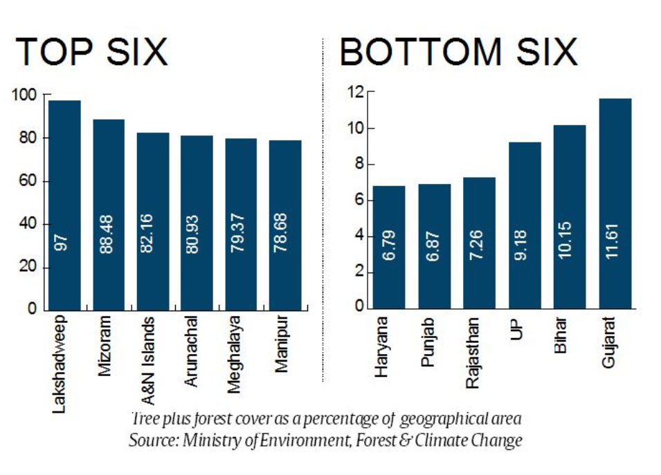
- According to the data, a quarter of India’s geographical area (24.49 %) is under forest and tree cover.
- Northeast crowds the list of states with most dense tree, forest cover.
- Manipur, Arunachal Pradesh, Mizoram and Meghalaya are among the top 6 states with highest forest and tree cover.
- The lowest forest and tree cover is in Haryana at 6.79 % of its geographical area. Punjab follows with 6.87 %.
- Top 3 States with maximum Forest cover (in terms of area):
- Madhya Pradesh (77,414 sq km)
- Arunachal Pradesh (66,964 sq km) and
- Chhattisgarh (55,547 sq).
- Top states with highest Forest cover in terms of percentage geographical area:
- Lakshadweep with (90.33%),
- Mizoram (86.27%) and
- Andaman & Nicobar Islands (81.73%)
- Rajasthan’s forest and tree cover is over 7.26% of its geographical area while Madhya Pradesh’s is 27.73 %.
- Top 5 States with maximum increase in forest cover,
- Andhra Pradesh (2141 sq km),
- Karnataka (1101 sq km)
- Kerala (1043 sq km),
- Odisha (885 sq kms) and
- Telangana (565 sq kms)
- Goa and Kerala are two other states with more than 50 per cent of their geographical area under forest and tree cover.
- Forest Survey of India (FSI) has been assessing the forest and tree resources of our country on a biennial basis since 1987.
- The results of the assessment are published in its biennial report titled “India State of Forest Report (ISFR)”.
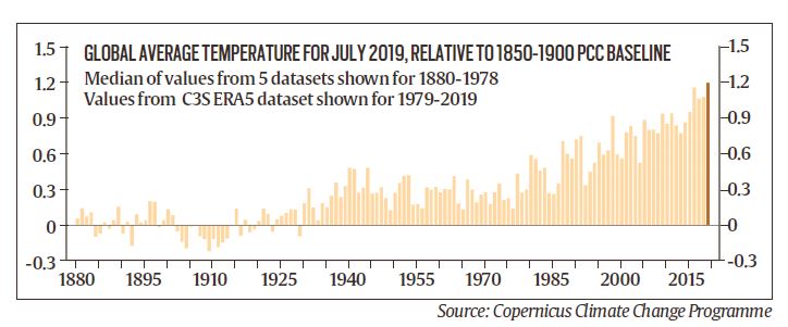
July 2019 was the hottest ever month
- July 2019 was the hottest ever month on record, announced by World Meteorological Organization (WMO)
- It was based on a new report from the European Union's Copernicus Climate Change Programme.
- July 2019 was close to 1.2°C above the pre-industrial level and 2019 has already logged several record-hot months.
- The month was characterized by relentless heat waves around the world.
- On July, numerous European countries including Belgium, Germany and the Netherlands experienced new national heat records with temperatures in excess of 104 degrees Fahrenheit.
- This year brought several severe heat waves to Europe, India, and Pakistan.
- The previous hottest month, July 2016, occurred during one of the strongest El Niños ever.
- The extraordinary heat was accompanied by dramatic ice melt in Greenland, in the Arctic and on European glaciers.
- The ice sheets of Greenland alone lost a staggering 217 billion tons of ice last month.
- It is enough to raise global average sea levels by 0.02 inches (0.5 millimeters).
- Meanwhile, unprecedented wildfires scorched so much of the Arctic, releasing about 100 megatons of carbon dioxide into the atmosphere
- The planet was already warmed up by about 1.8 F (1 C) above pre-industrial levels and are poised to hit the 2.7-degree threshold as soon as 2030.
Floods in Krishna river
- Krishna river, the lifeline of south-western Maharashtra, has wreaked havoc in the districts it flows through.
- Large tracts of land in Satara, Sangli, Kolhapur and Pune continue to remain under water.
- Dams dot the course of Krishna and her tributaries across Maharashtra, Karnataka, Andhra Pradesh and Telangana.
- These dams are the lifeline of western Maharashtra, and are a major supporting factor for the area’s sugarcane-based economy.
- Almatti, a major dam on Krishna, located in Karnataka, close to the Maharashtra border, controls the flow of water into the neighbouring state.
- The position of Almatti dam is unique, as this is the first dam on Krishna river after it leaves Maharashtra.
- The amount released from the dam is important to prevent any flooding upstream of Krishna, which is Maharashtra.
- Poor dam management, where the dam gates were opened suddenly, and the catchment areas were flooded.
- Dam management is an inter-departmental job.
- It involves close coordination between the departments of revenue, water resources and agriculture and the weather forecaster.
- The release of water is managed by taking into account the projected water usage for human consumption, agriculture and industries.
- In case of a weak monsoon, less water is released to tide over the non-monsoon months.
Krishna river
- Krishna River or Krishnaveni is one of the longest rivers in Peninsular India.
- It is the fourth largest river in India after the Ganga, Godavari and the Narmadha.
- It rises at Mahabaleswar in district Satara, Maharashtra and flows through Maharastra, Andhra Pradesh and Karnataka.
- The delta of this river is one of the most fertile regions in India.
- It was the home to ancient Satavahana and Ikshvaku Sun Dynasty kings.
- Vijayawada is the largest city on the River Krishna.
- The principal tributaries joining Krishna are the Ghataprabha, Malaprabha, Bhima, Tungabhadra and Musi River.
- ‘Polavaram’ right bank canal connects Godavari River to the Krishna river.
- ‘Agumbe’ which receives second highest rainfall (7,620 mm mean annual) in India, is located in the Krishna river basin.
- ‘Krishna Wildlife Sanctuary’ which harbors vast tracts of pristine mangrove forests is located here.
- The basin has a rich mineral deposits such as oil &gas, coal, iron, limestone, dolomite, gold, granite, laterite, uranium.
Source: PIB, The Indian Express
