Why in news?
A proposal for two time zones has come from the Council of Scientific & Industrial Research’s National Physical Laboratory (CSIR-NPL).
How is time defined and maintained?
- If lines of longitude are drawn exactly a degree apart, they will divide the Earth into 360 zones.
- As the Earth spins 360° in 24 hours, a longitudinal distance of 15° represents 1 hour.
- In other words, 1° represents a time separation of 4 minutes.
- So theoretically, the time zone followed by any place should relate to its longitudinal distance from any other place.
- Political boundaries mean that time zones are often demarcated by bent lines rather than straight lines of longitude.
- This is the “legal time”, as defined by a country’s law.
- The geographic “zero line” runs through Greenwich, London.
- It identifies the GMT (Greenwich Mean Time), now known as Universal Coordinated Time (UTC).
- It is maintained by the Bureau of Weights and Measures (BIPM) in France.
- The United States follows several time zones across its breadth.
What is the case with India?
- The Indian Standard Time (IST) is maintained by CSIR-NPL.
- The Indian Standard Time (IST) is based on a line of longitude that runs through Mirzapur in UP.
- At 82°33’E, the line is 82.5° east of Greenwich, or 5 hours 30 minutes ahead of UCT.
- But notably, India extends from 68°7’E to 97°25’E (spread of 29°), representing almost two hours from the geographic perspective.
- Evidently, there is huge difference in daylight times between the country’s longitudinal extremes.
- So the early sunrise in the easternmost parts causes the loss of many daylight hours by the time offices or educational institutions open.
- Also, the early sunset in the region, leads to higher consumption of electricity and concerns over the costs associated it.
- Thus, over the years, there have been demands and debates over India having two separate time zones.
- Concern - Those against the idea cite the impracticability of having different time zones.
- Particularly the risk of railway accidents is cited, given the need to reset times at every crossing from one time zone into another.
- The government has also, in the past, not favoured two time zones citing the complexities involved.
What is the recent proposal?
- The CSIR-NPL has published a research article describing the necessity of two time zones.
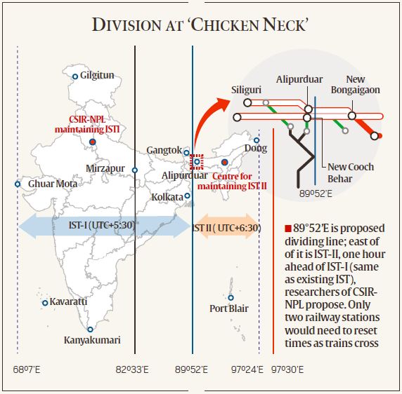
- It has proposed a new time zone with an hour ahead of the existing time zone.
- It proposes to call the two time zones IST-I (UTC + 5.30 h) and IST-II (UTC + 6.30 h).
- The proposed line of demarcation is at 89°52’E, the narrow border between Assam and West Bengal.
- States west of the line would follow IST-I, and states east of the line would follow IST-II.
- The latter include Assam, Meghalaya, Nagaland, Arunanchal Pradesh, Manipur, Mizoram, Tripura, and Andaman & Nicobar Islands.
- To make the idea possible, CSIR-NPL would need a second laboratory in the new time zone.
- CSIR-NPL already has the technical expertise to duplicate its existing facility, but the move would require legislative sanction.
What is the rationale?
- The “chicken neck”, connecting Northeast to the rest of India, is where the two time zones will be demarcated from each other.
- Railways - The railway signals have not yet been fully automated in the country.
- In this line, the border between the two time zones has a very narrow spatial-width with minimum number of train stations.
- So the train timings, while crossing the border, can be managed manually without any untoward incidents.
- Energy - The country could potentially save 20 million kWh energy a year if it follows two time zones.
- Besides, the importance of synchronising office hours as well as biological activities to sunrise and sunset timings was analysed.
Source: Indian Express
